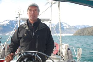
s/v Raynad in ALASKA -Summer 2012

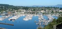
KODIAK – ALASKA! – May 14, 2012 – ( 57-47.15N / 152-24.61W)
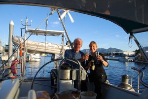
St Paul’s Harbor,Slip D17, Kodiak – Snowing! John & Doug arrived safely.
June 26, 2012 – KODIAK, Alaska
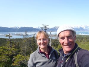
John and I are at last reunited in Kodiak. After a very cold night and rainy day, the sun has at last broken through and it’s really beautiful.

John’s working on getting our heating system up and running since it’s pretty darn cold (low 50s). I’ve vacuum packed the tropical weather clothes and will work on reorganizing the boat a bit, laundry/cleaning, and provisioning for our ongoing travels. The local harbor master and his wife had us out to their home for dinner tonight – they run a beautiful bed and breakfast right on the waterfront overlooking the cliffs and islands across the channel. It was truly magical and her gourmet food – a “fish sampling” of smoked black cod, sockeye salmon and snapper- was superb.
 While there, the sun came out and we watched the magical effects created by various shafts of sunlight. Seems like there are many, many lovely bays for us to visit just around Kodiak Island.

June 30, 2012 (57-53.39N/ 152-37.70W)
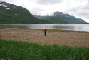
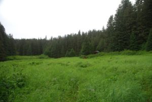
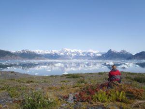
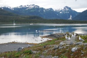
Anton Larson Bay Anchorage – Gorgeous!!
John and Kristy have finally left the harbor in Kodiak and are now anchored in the lovely Anton Larson Bay. GT’s in hand, sun about to set, snow crested peaks, rocky, green islets, absolutely peaceful, sunny and spectacular!! This is all that we have dreamed of over the past 3 months:)
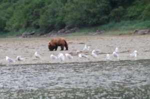
July 1, 2012 – 57-56.94N / 153-02.68W
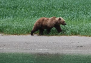
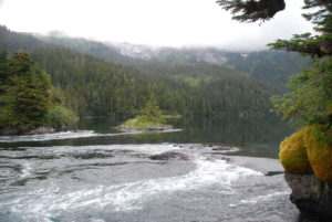
Dry Spruce Bay, Kodiak Island : Bear on beach-lots of sea otters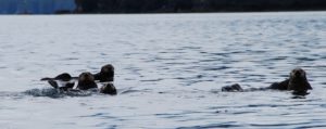
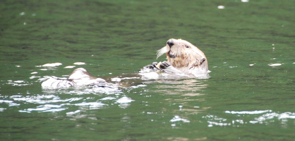
Just as we were dropping the anchor, I looked up and saw a big Kodiak Brown Bear walking along the beach right in front of us! That was very exciting. 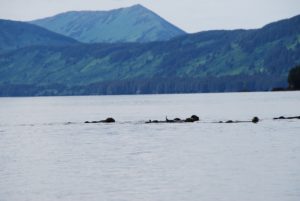 Meanwhile, we are surrounded by rafts of sea otter, they are huge and really cute. We’re in Dry Spruce Bay where there is a defunct cannery and other abandoned properties, including an old wrecked and grounded dock complete with utility hook-ups. No wind today, so we’ll wait until the 15-20kts forecast for tomorrow to make our crossing over Shelikof Straits to Geographic Bay. We’re hoping to celebrate our 30th anniversary on July 3rd amongst the majesty of glacial peaks.
We realized after getting to Dry Spruce and splashing our dingy in the water for the first time, that we had forgotten to get more petrol! We’d given most of it away in the outer atolls of the Marshall Islands. We’re now hoping that we can maybe buy a gallon or two off of a fishing boat, or someone on shore?? If not, we have a little bit, but our explorations will be curtailed.
Date/Time: 2012/07/02 (57-59.66N /153-12.61W)
Comment: On route to Geographic Bay

July 2, 2012 – (58-04.17N /154-22.72W)
COMMENT: Just entering Geographic Bay
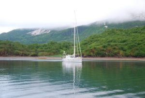
JULY 3, 2012 – Misty 30th ANNIVERSARY!!
(58-06.88N / 154-36.25W)
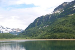
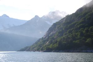
Geographic Bay in the Alaska Peninsula Katmai Refuge

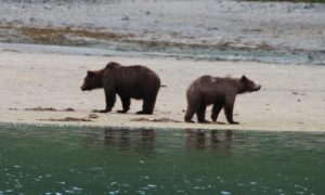
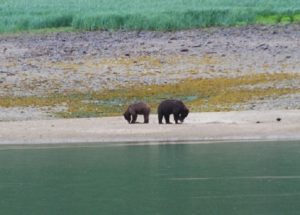
We entered the magical Geographic Bay on the Alaska Katmai Peninsula yesterday evening and just after dropping anchor, what should appear but two bears on the beach! It’s absolutely silent here but for the song of the birds, squawks of the seagull, and the occasional visiting float plane. 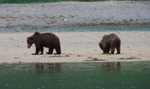 We awakened this morning to the sounds of rain on the pilothouse and now over morning coffee, are watching four bears on the beach! The same two as last night have come back with the low tide and there is one on each of the two other distant beaches.

They are out rooting like pigs in the swampy muck of low tide in this estuary surrounded by steep mountains and towering cliffs completely void of any trees – as John said, it’s a bit like boating in Glencoe with the low misty clouds, fog and cold rain. It’s almost eerie this feeling of solitude.
We’ll probably launch the dingy soon and donning our full rain gear, go exploring…maybe just via water on account of all the beaches being patrolled by bears!?!?So it’s a misty wilderness anniversary – our 30th – unbelievable.
 John and I were just reflecting this morning on some of the exotic locations we’ve been for our anniversaries. Of course the best and most celebrated will always be our 25th on top of Kilimanjaro. This 30th is good, but a 19,000+ peak together with Jodie and Scott, is hard to beat:)
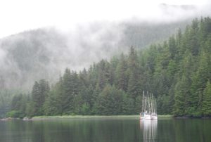
30th Anniversary in the Wilderness Bistro (s/v Raynad)
We were indeed the last people out of the restaurant:)Why else do you think that we actually saw the beautiful clear skies that suddenly happened at midnight!?!? A lovely finish to a very special day.
July 4th ,2012 – Geographic Bay, Alaska Peninsula
 Awakened to the sounds of rain pummeling down on the roof – seems today, like yesterday, will include many cups of tea! I guess after 30 years something has to bug you – turns out that my slurping of tea and other hot liquids is, “making my hair fall out,” says John!?!? Funny though, it’s really hard to drink hot stuff without a bit of slurp!?! Like yesterday, a mother and older cub are grubbing along the low tide. They’re lovely to watch – poor things must be absolutely soaked through and through. It’s really cute to watch them digging away.
 No fireworks or parades for us on July 4th – we’re just hoping for a few breaks in the clouds. This place would be absolutely stunning in clear, sunny weather. Since the forecast is for high winds and rain, and since this is an extremely well sheltered anchorage, we’ll probably just hunker down here with our little propane heater, lots of hot tea, good food and company, and the occasional forays out to explore our environment.
 We both enjoyed a very relaxed day yesterday with John reading cover to cover the Atlantic Monthly while I finished one book on the Nook and have nearly finished another. Our anniversary dinner included a late afternoon tea of homemade apple pound cake with vanilla ice cream consumed with hot rum:)

Then later large steaks, sautéed beans and salad with one of our NZ wines. Watched a weird movie, but nice all the same snuggling under three layers of comforters. Thank goodness for the small propane heater that Doug and John bought in Kodiak. We can’t run it all the time, but it definitely cuts the chill and keeps us warm enough. The fleece blanket/throws are definitely getting lots of use.Our new Danish friend on a lovely 65ft aluminum pilothouse boat, s/v Dana Felicia, arrived last night with his two female crew (his wife will not cruise any longer and so is back in Denmark with her kids and grandkids – he’s about 65.)
 We’ll likely get together with them later for drinks and eats – will be nice to have a bit of socializing. The best weather we’ve had so far was at midnight last night! Go figure, it cleared alot and the sky became many lovely hues of blue, with shafts of sunlight shining low through the valleys, calm and no rain. That’s why we were so surprised to see the rain back this morning, we’d thought after the beautiful clearing that we’d awaken to clear skies. This is a magnificent place, but with the low clouds and fog, it’s more like a scene from Tolkein.
July 5th, 2012
We took the side panels off of the boat windows yesterday, so now we can look out at the lovely majestic, cloud misted mountains around us and watch the water for wildlife and the beaches for bears without having to go outside:) The pilothouse advantage for sure! At low tide yesterday morning there were six bears scattered around on the various beaches – poor things must be absolutely sodden wet. Good thing they wear a bear coat:)
It’s yet another cold, rainy, misty day in GB. 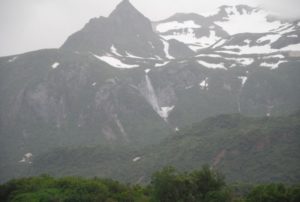 We enjoyed the company of our neighboring boat yesterday. They had us over for tea/coffee mid-day and then they all came over to our boat for evening drinks/snacks. It was really fun to have new people to socialize with for a bit. They too will be here today, so we’ll likely get together today too. One of the crew women, Lisa (age 64,) was a fashion designer in Montreal, Canada. The other crew, Kelly (44,) was a real estate agent in Florida, but has done lots of cool outdoor stuff like climbing Denali and trucking through Africa! The owner is Danish and he designed and had custom built a beautiful 65 foot aluminum pilothouse boat – it’s really lovely. Unfortunately, his wife has given up the cruising life, so he is alone on the boat with his adventures and various crew. He and John enjoyed talking about boats, engines, design, etc., while I had a lively discussion with Lisa and Kelly about travel, extreme adventures, etc.
So it’s more cups of tea, more baking and more books today while we watch for bears. According to the weather forecast, today is not a good day to go anywhere, so we’ll just enjoy our lovely, protected anchorage and perhaps wrap up in rain gear and go exploring a bit.
 July 6th – Geographic Harbor, Katmai Peninsula
We’ve been entertained by 5 bears this morning: a mother a older cub and three separate adult bears. The mother and cub were first out on the beach, drawing a crowd from the other two boats in the anchorage, so we just waited until everyone else cleared out and then went out in our dingy and alas another male came out across the river, and then another!
Mom of course, was not pleased with the new arrival and eventually when it was obvious that he was far too interested in them, she and the cub took off into the meadow grass and believe it of not, he followed! Let’s hope that’s not a sad story:( Patches of clearing sky and shafts of hopeful sunlight today. We’re now waiting to try and catch the right wind and tide to not only leave this anchorage through the narrow passes, but also to get across Shelikof Strait which is notorious for sharp, steep waves when wind is against the tide and with 20-25kts from the NE and the best time for crossing putting the tide coming in from the south, we’ll stay put a bit I think! Really lovely here anyway, despite the misty weather, and we’re still waiting for our part for the heater to arrive from Germany via Toronto to Kodiak. In the meantime, we have a small propane unit to cut the chill now and then and also water bottles filled with hot water and covered with a sock, and in the evenings a bit of heat for an hour with the generator. It’s pasta Friday:)

July 8th Geographic Harbor continues
Can you believe it, we’re down to our last 10 bags of Tetley Tea!?!? How could I have let this happen?? I guess we’ll just have to settle for what’s available at the stores in Kodiak – ugh! Must be the change of climate which has accelerated our tea consumption:) We’re also nearly through our 2nd bottle of Scotch – helped a bit by our friends who really seemed to like the warming glow from a tott.
 We were happily the first ones to spot Mr Big Blondie Bear this morning and so enjoyed our own private viewing from the safety of our dingy as he walked along the stones at the waters edge going between meadows/beaches. Big old guy that bear. Now there are two planes – a Grumen Goose and Beaver, so the BearZoo has begun. Not sure what happened with the bears we saw having a bit of an encounter – makes me wonder what bear stories we’re missing in the dense brush. No intension of investigating though! Thinking of you, but not planning on a visit to Harborzoo:) Colder this AM, hence the pot of tea.
July 9, 2012 ( 58-02.06N / 154-07.28W)
back toward Kodiak across Shelikof Strait
July 10, 2012 (57-56.91N /153-02.80W)
Overnight in Dry Spruce to make tide this AM
 Funny Story:
Last night we were woken up by the sound of feet and sliding on back deck. When I looked outside, I was met with the perky face of what I think was a land otter, or possibly a seal, who had decided to “play” on our boat. Persistent little dude, and friends, used our boat as their private jungle gym for about 2 hours last night! Now this morning all that is left is their mess – the head of a small halibut and some other blood and smeared guts – yuck! It was really cute to see him perk up and look at me last night though, so all we can do is laugh and get out the cleaning bucket:) A friend of ours who took his boat to the Galapagos had some really cute pictures of the seals using his swim step and back deck as their own private abode!
July 13, 2012- St Paul’s Harbor Kodiak
July 14, 2012 Kodiak Island, Alaska (57-50.60N /152-16.29W)
Sailing north
Happy Hour was had by many in the cockpit last night – and even with sunshine! Tom and Laura came over, as did their friend Anna – a crusty and well seasoned ‘ole fishing gal, and four other boaties! We missed you – should have been here:) Tom and Laura send their greetings. Thank you for connecting us, even if for only a little while, it’s always great to have friends. Tom even came down and threw our lines at the dock this AM which was appreciated. Now we are off to explore more of the islands and bays around Kodiak before heading across toward Kenai.
July 14, 2012 (58-09.02N / 152-19.10W)
Brisk broadreach to Izhut Bay now anchored
Beautiful anchorage, but raining and windy, super gales throughout the night!
 July 15, 2012 (58-22.89N /152-16.54W)
Seal Bay northern Afognak Island
Very calm and peaceful anchorage.
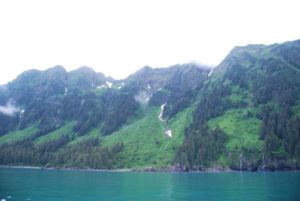
Such a different experience this navigating into dark waters! Yesterday we sailed mostly on a broad reach, briskly around from Kodiak into the lovely and very welcome Izhut Bay. With the wind and rains coming into the cockpit, I was thoroughly chilled despite my winter running tights, Mountain Hardware windstopper fleece and three layers on top. Always more daring than me, Captain John pushed us into the bay beyond my safety zone to finally anchor between two island cliffs in what seemed calm and safe waters. Happily anchored, especially since the serious rain started pouring down, we shared some pasta and wine then settled in for the night. 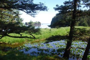 Throughout the night we had gusts from the projected gales shaking about, good thing we were snug and safe. After morning coffee, we lifted anchor only to find a large ball of kelp wrapped around the anchor…many chops and trials later, we set out to shoot through Marmot Strait with the incoming tide. Getting the tides is a significant timing issue here – make the tide and we cruise at 9+kts, miss it and we struggle to maintain 2kts. We’re learning though and so enjoyed 9.8kts through Whale Passage and 8+kts through Marmot:) Now we’re relaxing with the slow sunset in tranquil Seal Bay, way down deep into the cove and a skinny inlet. Once again, Captain John forged ahead despite the chart stating 2m depths, and we’re safely anchored in 5-9m of water.
 Just had an unexpected visit from the Afognak Lodge aluminum charter boat filled with crew and friends(we’d thought it was a marine research base, but were wrong.) Nice group, although they gave us a bit of a startle as they came roaring up asking us for our permits and licenses!?! Of course with beers in hand, they hardly looked serious, but potentially irritating. A fun group of young people, the makers of the boat up from Port Angeles and the lodge crew – no guests today so they’re partying. We’ve been invited for dinner tomorrow night.
Life is good and peaceful.
July 17,2012 (58-30.36N /152-24.97W)
Andreon Bay east Shuyak Island
 No we are not hung up on the low tides, nor are we still partying with a boat full of people. Just me and John venturing from bay to bay. We met a man in Kodiak who retired at 47 (he was an ophthalmologist) and spends 6 mos of every year up here. He recommended several spots which we are busy exploring. Some have been a bit of a stretch since the maps do not give information on many small bay areas….but we haven’t ended up high and dry yet!?!? It’s really lovely and peaceful here, no other people or boats. We were visited by a rowdy group from one of the fishing lodges a few nights ago and then they roared up to us as we were leaving and gave us a big red snapper!! I guess they took pity on these poor old farts who can’t seem to catch anything. Good eating though:) Tonight is stew night, the pressure cooker is gently spitting and I’m hoping the meat will be duly tenderized. Any and all pressure cooker tips/recipes will be appreciated.
July 18, 20102 – Big Bay, Suyak Island
 We’ve just dropped anchor in the lovely Big Bay on the western side of Shuyak Island north of Kodiak. After motoring down the east side of Shuyak with super glassy water and being entertained by lots of feeding humpbacks, we enjoyed a gorgeous fast romp with the tide through the narrow Shuyak Strait hitting speeds of 11.8 kts! As we cleared the straits, we were rewarded with a view of the very impressive Alaska Peninsula on a sunny clear day; the grand snow covered, glacial peaks are spectacular – how lucky we are to have a clear day!
 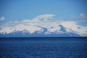 We could even see the tops of Mt Augustine, Mt Iliamna and Mt Redoubt volcanoes at 10,000+ feet with Mt Douglas just peaking over the horizon – it’s broad, white glacier covered top shining out from the bluebird sky. As we dropped anchor, three deer decided to swim across from the small island in front of us to the other side of the bay. It all promises to be yet another special day:)
Yesterday morning, we explored the Little Waterfall Fish Ladder Enhancement cabin. No one was there, except LOTS of bear prints and poop, had my heartrate up pretty high for the entire hike up from the bay to the waterfall. Poor John endured my loud talking/singing as our only bear deterrent. We need to rig up a tin can with rocks to shake, my repertoire is pretty poor when my memory is so distracted. We did buy a can of bear spray, but have yet to arm ourselves with anything more powerful, so the Kissinger voice will have to do it!!?!?
After moving yesterday to our new anchorage at Big Four Island, Andrean Bay, we dingied around to explore an abandoned homestead and wrecked freighter. Apparently the owner had died in a boating accident a few years ago, and his widow just up and moved to Kodiak leaving everything behind. His tool shed was completely organized and the house still had magazines, his coats and work clothes hanging on hooks, kitchen things, and other the little homey stuff – amazing. We were once again visited by a family of river otters last night, but with the dingy down love, they did not come aboard, only frolicked around the boat:)
We’re thinking of leaving early tomorrow and make the crossing to Seldovia (south of Homer on the Kenai Peninsula.) In the meantime, we’re out to soak up the sun and explore all the many coves of Big Bay.
 July 19, 2012 – Big Bay, Suyak Island
It’s been a glorious day of sunshine, still glowing strongly at 8:00pm. We had a great hike up to the highest summit here (only 590ft) and took in a wonderful view out over Shelikof Strait to the Katmai, Alaska Peninsula up Cook Inlet over the Barren Islands and all the way to the Kenai Peninsula. Try as we did to get good photos, the scene was just too large to really capture. It was just great to finally bask in the sun again and once back from our exertions, to even relax in the cockpit (GT in hand) with my sunglasses on reading a book! We haven’t done that since the Marshall Islands!?!? It has felt fantastic. Now we must force ourselves to close out the night for an early rise to make our passage to Seldovia (75nm,) we hope. The winds will be strong, but good and we need to leave early to catch the tides and hope to get most of the way to Seldovia before the Cook Inlet starts flowing against us.
July 20, 2012
(58-56.31N / 152-31.49W),Speed: 7.9; Course: 021T
passing the Barren Islands
 July 20, 2012 (59-24.87N / 151-42.81W)
Anchored in Seldovia, Alaska
After enjoying several beautiful beautiful, absolutely gorgeous days around the Afognak and Shuyak Islands north of Kodiak where we did lots of hiking and exploring in total isolation, except for lots of sea otters and a few deer, bear sign too but we didn’t encounter any bears because I make lots of racket.
Shelikof Strait to Cook Straits Crossing – Story:
 We decided to move on across Shelikof and Cook Straits to Seldovia. What we ended up with yesterday was a crazy, scary day starting first at 2:30am when our anchor lost hold during gusty winds and we had to reset it in the dark – neither of us really got sleep after that and then at 6am we set out on a very tidal passage through the narrow channels and bashing through the waves coming out of Big Bay – wind against tide heading into not just the 25kts predicted, but also what quickly became 40kts of wind. At first we headed north on a fast broad reach with the tide pushing us from behind. A bit rolly, but ok and we were happy to be making such fast progress. We had anticipated this tidal current so were happy. Passing the Barren Islands and crossing broadside to Kennedy Passage however, we got hit unexpectedly with a strong 3kt west setting tidal current from the Gulf against the already 40kt winds which created some awesomely steep, short waves. Scary enough that for the first time, Captain John who had already suggested we harness in, also decided that we should put the companionway boards in and none too soon as we nearly got knocked down! What a moment to have the boat pushed so far over, and then thanks to her great stability factor (LPS- limit of positive stability,) she came back up before getting hit again. For a few hours we had lots of water over the foredeck and waves clumping into the stern splashing us with water, but Raynad kept on going. Shortly thereafter, John suddenly shouted – “Oh my God it’s a whale right there!” and we watched helplessly as it tried to dive beneath our bow, then either it or another whale, seemed to roll itself along the hull of our boat. We saw one giant flipper over the starboard side next to John’s shoulder, then a long,white whale belly nearly the length of our boat, then another giant flipper and finally a tail came up just at the stern like something out of Moby Dick – I thought it might crash down on us, but it just dove deep – we think. No sounds or feels of impact, but that was so incredibly and unbelievably close, we could have shook hands with it. We really hope the whale is ok. There was absolutely nothing we could have done, especially while under sail with no warning and in such tough conditions. Throughout this trip, we’ve had some close encounters with whales, but when the seas are calmer, we can see them coming and at least try to avoid them, not so with this one.
 Once we entered Cook Inlet toward Katchemak Bay, the weather calmed and believe it or not before reaching our destination, we actually had to motor! Go figure – one moment we’re in death defying waters and the next we are nearly becalmed!?!? We were so glad to at last enter Seldovia Bay and drop anchor at 8pm. A couple of drinks and we were lights out exhausted from the long and unexpectedly exerting day passage. 15 hours of sleep later, we’re enjoying hot coffee and looking at the spectacular views through the heated comfort of our pilothouse windows:) We took the side panels off, so we have only the glass windows. This boat was truly well designed for this climate and even without the safety panels, the windows survived the test of yesterdays wave bashing. Off to explore the town!
July 22, 2012 (59-13.11N /151-43.88W)
Port Chatham overnight
We’re doing just shorter day trips now after our harrowing trip across the Straits to Seldovia. We’re anchored in Port Chatham after a 6am start, so we’ll leave here early tomorrow and continue on our way another 40 miles to the next protected inlet. We’d like to visit Northwest Fjord where there are supposed to be some great glaciers, and then will make our way to Prince William Sound. We really, really tried to catch a halibut today, but only got a nibble that took the bait and then got snagged up and had to cut the line:( Bummer. We kept at it, but no luck, so it’s chicken for us tonight. We’d be pretty hungry if we depended on our subsistence resources.
Rainy, cold, misty day so it’s cups of tea, maybe some baking and of course reading:)
July 23, 2012 (59-18.49N /150-56.47W)
Tonsina Bay in Nuka Passage
Had a rather dismal day of wind against tide, gray rainy foggy motoring, but at last we are anchored in a lovely cove which will only get more lovely if the clouds will lift and a bit of sun appear. We’re just entering the glacial areas of the Kenai Peninsula so the water is that milky green, the mts steep with lots of waterfalls and we spotted the first glacier coming down to the water. Now if the weather will cooperate it could be quite spectacular. For now though, I’ve had my HOT shower and am settling in with the Nook:)
59:10.879 North
150:57.781 West
Floatsam Reporting done by KT, announced by USCG Security Warning:
Yesterday at 11:00AM AK time, we found a large floating bit of trash aprox 40 feet by 16 feet consisting of what appeared to be two tanks attached.
Location: south of Gore Point
July 24, 2012
Thunder Bay (59-34.32N /150-11.52W)

TAZ BAY -(59-39.12N /149-48.94W )- Amazingly-spectacular!!
 So here we are in the most incredible bay – steep cliffs, trees, waterfalls…..AND the sun is shining. After a touchy pass through the rocks (we actually launched the dingy and John went scouting ahead) – we are safely anchored in Taz Basin! So, out come the GT’s (of course:) BUT it’s the last bit of tonic:( Nonetheless, John had to use this moment of dryness and sunshine to chip off paint and work on the rust (go figure!?!??) but while looking for bits….he found TONIC!!!!!) Knew you’d appreciate that. Secret stores win the day!!!! Yes, I have had a couple. Yesterday was misery itself, so today is so, so, so appreciated!
 While John was chipping and grinding…I went out in the dingy and hopefully got some good photos, but mostly just enjoyed my surroundings. The hills literally fall with water. Little lovely waterfalls cascade everywhere.
Tomorrow we journey to Northwest Fjord and the real glacier world (complete with ice banging on the hull??)
Yesterday was misery itself, so today is so, so, so appreciated!– Each day has begun at 5AM in rain and drizzle, this sunshine felt SO good! Of course we HAD to visit TAZ BASIN (our chocolate labrador is called Taz.) As soon as I saw the name, I started to investigate the area. A really , really tough pass, yet with a calm and sunny day it was no problem. John got to work right away on some paint work that he’s been keen to do, so I first started reading and then decided to skiff about and take some photographs. Now after eating dinner, the bugs have found us, so we’re putting in the boards. John is out for a spin around the lagoon. We really needed this sunshine.
 July 25, 2012 – Northwestern Fjord (59°25.20’N/ 150°33.98’W)
We had a super day yesterday, started out cold-misty-rainy, but soon the skies broke up and eventually we were motoring over glassy waters and warm blue skies through some amazing passages and along huge, granite cliff islands on the southeast in of the Kenai Peninsula.  The vistas are impossible to truly photo – Thunder Cove with it’s massive waterfall tumbling over the cliffs, plus about a 1000 other cascades of various sizes falling off each of the many surrounding cliffs. We anchored for the night in Taz Basin a small, deep hole surrounded on 3 sides by towering cliffs with trees and shrubs clinging to every crevice and the entrance made via a frighteningly small opening between the rocks! The beauty and sun were so overwhelming, we just had to open GT happy hour and soak up the moment:) It wasn’t long though before we were both energized to action – John fixing some paint work (chipping, grinding, painting) while I motored around in the dingy trying to get some good photos. Exhausted after our early 5am starts over the past few days, we were both snoring by 10pm and missed the midnight sunset.
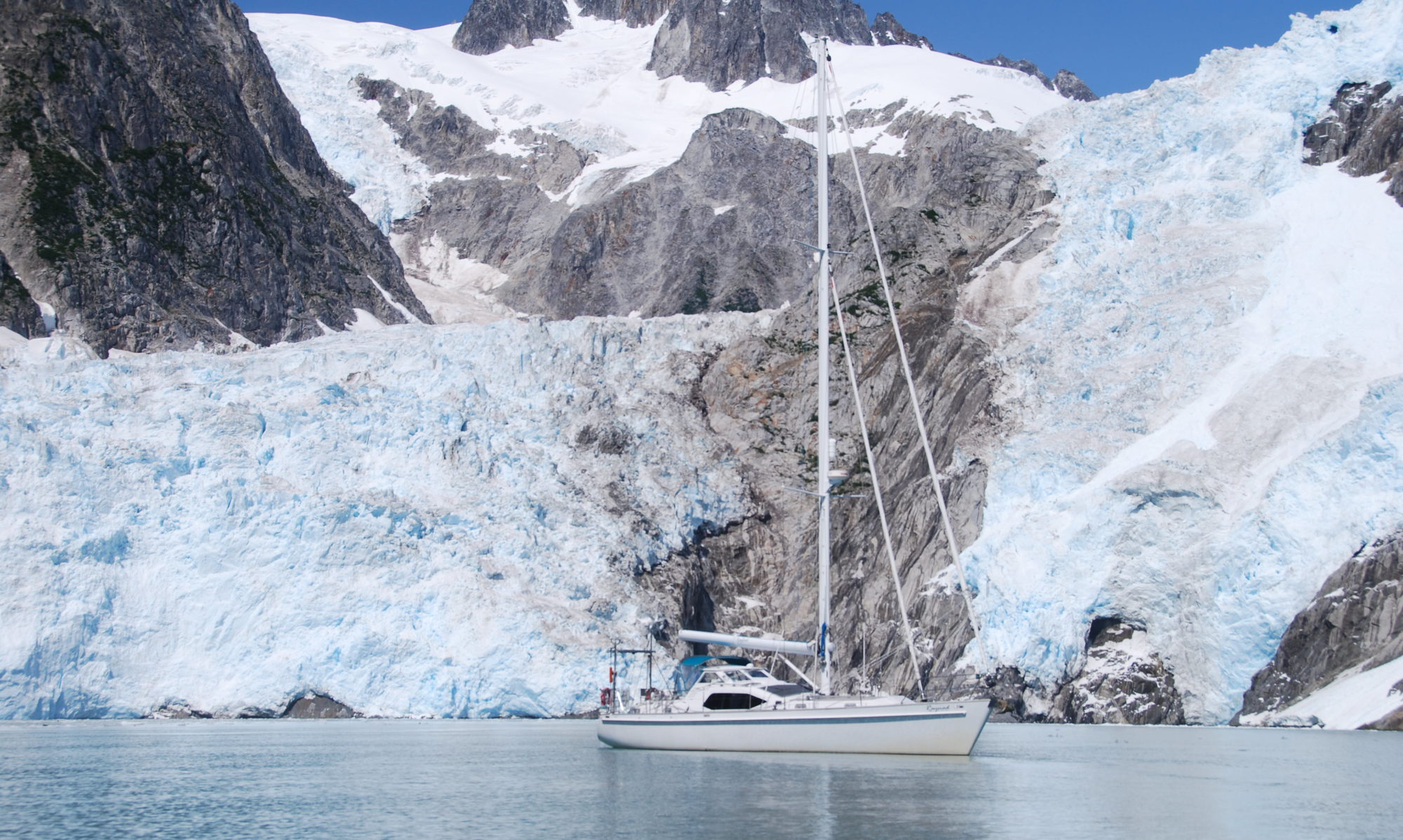
Another clear blue day today, as long as the fog bank on the horizon stays clear of us. We shall venture forth into Northwestern Fjord where the fingers of several glaciers come down to the tidelands. John is out cleaning the hull with hopes of getting that calendar perfect photo of Raynad next to glacial blue walls of ice! He thinks we’ll have the sails up – if so then it’ll have to be me in the dingy because if this boat starts to sail off and I’m the only crew onboard, it would be a problem!?!?
 July 26, 2012 – Current Position – 59°47.94’N 150°01.06’W
Northeast Bight of Northwest Fjord – Spectacular!
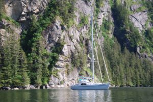
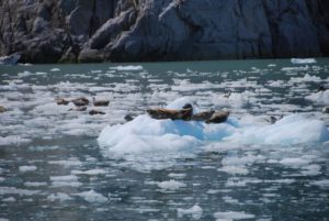
Yes, we are in the picture perfect Alaskan fjord surrounded by glaciers, seals and spectacularly rugged beauty.  Two smallish cruise boats came mid-day, but after they left, we’ve had the entire place to ourselves. Some great photographs:) Even toasted the day with GT’s made with glacial ice – Captain John went out in the dingy to get the “perfect” photo of Raynad, while I maneuvered her about, per his instructions.
 Tough job getting good ice, without seal poop, and not too hard to chip off. We really enjoyed several hours of afternoon sunshine while watching the seals on their ice flows and gasping at the occasional ice calving. The power of nature is truly humbling. Safely anchored, the sun is still out. A huge fog bank raced us up to the fjord this morning and then has lingered all day, let’s hope it stays back for at least the evening. We are SO glad that we didn’t hesitate, but just took off from Taz Basin a couple hours earlier than expected, because just after we left, we watched the fog completely fill and surround our beautiful anchorage! Life is good:)
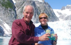

July 27, 2012
We tried to hike the glacial moraine today, but didn’t get all that far since the rivers were either too deep to cross, sided by cliffs, or absolutely clogged with low bush Alder. Nice to wander a bit though and the sparkling fools gold beaches were quite fun. After repeating yesterdays visit to the Anchor and Ogive Glaciers to watch them calving and pester the Stellar Sea Lion trying to sleep on their little ice flows:) we are now anchored next to the lovely Erratic Island directly across from the other arms of the Anchor and Ogive where we listen and feel their rumblings. Could be a restless night, but the view is spectacular, the sun is out and it’s HAPPY HOUR!!
July 28, 2012 (LATITUDE: 59-36.54N / LONGITUDE: 149-38.96W ) COURSE: 104T;SPEED: 5.5
Transitting Chiswell Islands in the fog!
Rest Stop at- LATITUDE: 59-45.34N / LONGITUDE: 149-35.42W – Paradise Bay for lunch
ABRA COVE – Ailik Bay (59-53.74N / 149-39.22W)
Gorgeous sunny evening!
 We are having several amazing days amongst the glaciers of the Kenai Peninsula. Yesterday evening was magical as we were so close and looked out at several different glaciers, red striated rocks islands, ice flows, seals…very special:) Today we left the beautiful blue Northwestern Fjord and ended up transitting through patchy fog, our visibility alternating with each mile. Sometimes it was mystically beautiful, other times a bit scary and blindingly white, then the vista would suddenly open. A bit frustrating since what we were passing through was some reportedly unique scenery of granite cliffs, Puffin colonies, sea lions, etc…We ended up having a sunny and relaxing time bobbing about Paradise Cove for our lunch, trying to catch a fish (nada) and then making our way over to the Holgate Arm glacier after the cruise boats left.
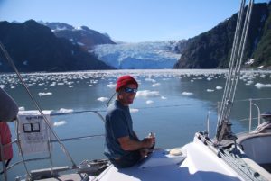 The sun was out and John even put on his Speedo suit to go out in the dingy amongst the ice chunks and take pictures, get more GT ice, and just have fun. A couple of kayakers were also bobbing about. Eventually we motored up and made our way to this lovely anchorage nestled in a cove of waterfalls and looking out over the glassy water to the glacier across the bay. This is the quintessential Alaska that everyone pays the big money for and I guess was also what we were looking for when we made the decision to leave the hot, white sand beaches of the South Pacific and sail the North Pacific oceans!
July 29, 2012 (60-00.74N / 149-17.72W)
 Anchored Thumb Cove after cold, rainy day
We’re anchored about 8 miles south of Seward in Thumb Bay which is a pretty cove with LOTS of other boats in it. Mostly sports fishing craft and smaller sailboats, probably locals. We had a tough time getting our own little share of the scant anchorable areas, but did well enough and had a great night’s sleep. It’s still rainy with low clouds and occasionally near white out fog, but when the clouds lift a bit, the scenery is lovely. Nice to have the pilothouse windows to look out and enjoy the views without having to get wet/cold. Doesn’t work so well while on passage, but with the new heating systems working, quite cozy once we drop anchor:)
July 30-31, 2012 Seward, Alaska Transient Marina
Visited Sea Life Center, did laundry, shopped, had a dinner out, met new friends on s/v Capella III. Left the harbor late after refueling, dropped anchor back in Thumb Cove. Should have listened to the weather- now we’re out here when we’d really rather be back in the cozy marina with wifi, phone and no worries about dragging anchors in the 25-35kt winds and whirlies.
Aug 1, 2012 (60-00.25N / 149-18.16W)
Anchored – Snotty weather will wait it out here
We had hoped to sneak out and around the cape this morning before the weather turned, but no go, the winds suddenly switched just as we were getting ready to go, so we have only changed our anchoring and are still in Thumb Cove, not the best protection, but at least we’re not out in the nasty seas. Too bad we didn’t just stay in Seward for a couple more nights. It’s a busy, crowded harbor, so with the high gusty winds, we’re not keen to try and go back in and safely get into a slip among the many other, very expensive boats!?!? Just us and a fishing boat out here plus the small skiff that the campers on shore have used. There are two public use cabins on land. Will be a day of fussing over the anchorage, drinking tea and reading.
August 3, 2012
Woke up this morning and decided to just go all the way out in the Gulf and sail across toward Prince Williams Sound while the winds will allow us to do that. Better weather than expected, even a bit of sunshine! We’re on a rolly beam reach with 15kt winds and our speed is slowly climbing toward 6.0kts. We’re hoping to anchor tonight somewhere around Sanson Bay or Auk Bay and then take one of the passages into the main sound tomorrow.
LATITUDE: 59-58.29N / LONGITUDE: 148-10.34W
 Fox Farm Cove just outside passages into PW Sound
Guess this anchorage got it’s name due to a fox farm being here at some historic time, but for now, it’s much like many areas of SE Alaska complete with a few sea otters, jumping humpies (Pink salmon) but no bears. When we arrived another boat was at the “best” of the two anchoring spots and their helicopter arrived just as we were setting our anchor! Such high-life company…guess they didn’t approve of the new neighbors (even though we are at least 1-2nm across from them on another shore) so the helicopter took off again and the boat left. We’re thinking it’s some sort of commercial operation out of Seward since on closer inspection the base boat was pretty basic – sort of a fuel barge really and nothing all that fancy. So, we have te bay to ourselves. Still no bears – we were spoiled in Geographic Bay with the brown bears coming down every low tide:) It’s all blacks here we’re told. The crossing was much less rough than expected, once we cleared Cape Resurrection and the washing-machine slapping swells…we had a pretty steady ocean swell and winds of 10-20kts, so sailed some and motor-sailed some. Tomorrow we’ll go into the Sound. John has marked several great anchorages which were recommended by our new sailing friends in Seward. Everyone says that you could spend 1-2-3+ seasons just in PW Sound. We’ll do about 7-10 days and then likely make our way more southward. Forecasts of old seadogs are saying that the season will be shortened and more frequent gales/storms come late Aug/Sept, so we’d like to be further along by then. It was great to have the sun come out today for some of our trip. Happy hour and dinner in the cockpit, now after hot showers, we’ll call it a day:)
August 4, 2012 LATITUDE: 59-59.63N /LONGITUDE: 148-10.10W; COURSE: 002T; SPEED: 6.0
Heading up Prince of Wales Passage
LATITUDE: 60-21.79N /LONGITUDE: 148-13.49W
 Seven Fathom Lagoon inside Jackpot Bay
We are snuggly anchored inside Seven Fathom Cove which is a fully protected salt water pond approached through a rather narrow passage. I was a bit reluctant to try and go through since MaxSea says there are two rocks in the passage and gives no indication of safety, but the PWSound guide said that the rocks were not mid passage and could be avoided with a close lookout and staying mid-channel!?! Love my Maui Jim sunglasses – they really do give the best visibility through the water, but it’s tough here with this dark stuff – not much warning about obstructions. We’re having a leisurely Saturday morning of coffee and no stress to move on since we will only motor around the islands a bit to another anchorage. Should be more low-key now that we’re in the sound. Next big crossing will be across the Gulf to SE, but probably not for a couple of weeks.
Yesterday surprised us with a lovely, sunny afternoon. We’d made our way up through the Prince of Wales Passage into PW Sound and then across to Jackpot Bay where we tried a bit of fishing, no success, before coming into this cove.
August 5, 2012
LATITUDE: 60-23.90N/ LONGITUDE: 148-09.14W
Ewan Bay near Skookum-chuck. Whales, otters and birds
 August 6, 2012
LATITUDE: 60-24.67N / LONGITUDE: 148-04.89W
Paddy Bay overnight
We moved one bay over (big trip!?!?) and are now in Paddy Bay. The last anchorage had a skookum-chuck which is a tidal lagoon with an out/inflow that fills or empties like a river with each change of the tide. It was pretty interesting to see and we took the dingy over to explore, although we couldn’t go into the lagoon because of the rocks. It’s like a little waterfall when the lagoon empties and an incredible rush of rapids when it fills up. We’d hoped to see more wildlife since the guidebook said that mother otters used this area to train their young. Only saw one pair and not much action. Whales were there when we arrived, but quickly took off:( Mostly we were visited by mosquitoes – argh! Rainy and cold here, so we cleaned the boat this morning – a big job of relocating stuff – but it’s better now. Now it’s a cup of tea as we wait for happy hour and pasta (missed Friday pasta night, so it’s now a Sunday pasta:)
August 7, 2012
LATITUDE: 60-26.88N /LONGITUDE: 147-59.85W
So Eshamy Bay & Lagoon Anchorage
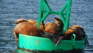
We’re just dawdling along. Yesterday was an indoor, rainy day spent reading Atlantic Magazines cover-to-cover and drinking lots of tea! A little break in the weather after dinner (hot & sour soup) so we dropped the dingy and went exploring the shoreline, tried to snag a salmon and pestered the bears.  Sunshine broke through the clouds this morning which made our short trip over to Eshamy Bay and Lagoon very pleasant. We came into our anchorage while entertained by the Stellar Sea Lions on the rocks and otters furiously eating, dropped anchor and then watched a couple of black bears:)
After launching the dingy, we went exploring the 2 mile lagoon – more otters and bears and lots of jumping Pink Salmon. This whole area has been declared a State Marine Park , land purchased and so dedicated by the Valdez Oil Spill Trustees. Tomorrow we’ll make our way over to the Port Nellie Juan Glacier. Mostly shorter day trips between anchorages, which is a nice change.
August 8, 20120
LATITUDE: 60-28.44N /LONGITUDE: 148-19.17W
Nellie Juan Glacier – anchored at Nellie’s Rest
 August 10, 2012- 60-35.70N /148-14.71W
Little Mink Island Anchorage
Despite the break in the clouds last night and the beautiful crescent moon at midnight…we awoke to misty clouds laying lowly over the mountains. After an extra pot of tea, we decided that the weather probably wouldn’t clear enough to see the striking granite cliffs and ice fields of Nellie Juan Glacier, so we took off and are now anchored amongst the quaint coves of the Mink Islands. No mink to be seen, but LOTS of flipping/dying salmon, eagles and a gorgeous black bear! Immediately after dropping anchor, we took off in the dingy to explore the inlets and were able to just float at the mouth of the river and watch a young black bear make his way along the shoreline, munching on a post-salmon snack of grass, sniffy-farting-pooping and then wandering off into the woods. Now it’s high tide and all the wildlife are at rest – and so shall we.
Hoping for clearer skies tomorrow as we make our way toward the Columbia Bay glaciers.
August 11, 2012
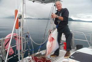 We caught a HALIBUT!! We set out this morning in absolutely down to the water clouds/mist with my mind set on fishing for halibut (nothing to lose, the day was gloomy already!?!!?) We found the spot, set our anchor and started to jig. Two rockfish later….a halibut took hook and off we went~~!!!!! It was a comedy scene for sure as both John and I struggled to get this thrashing beastie under control!! Kristy realled it up to the boat, near the swim step….zing…off it went over the horizon (much worry about the actual length of our line) back up to the swim step…zing…out again. Fortunately John was by this time harnessed in and ready for battle! Halibut lost – John won. Pretty scary what he can do with a gaff!?!??
Best of all, during all of this activity, the sun came out:) After lots of skinning and cleaning- the halibut was packed in the freezer and a nice fresh portion sizzling in the frying pan. We were on the forward deck in time to enjoy a spectacular sunset. Full bellies on fresh caught seafood, sunset beauty AND GT’s/Whiskey…life continues to be good on board the good ship Raynad.

August 12, 2012
Columbia Glacier Fjord – a long fjord with many glaciers and miles of ice to navigate before reading the mouth of the Columbia.
Heather Bay – Spectacular sunset
We motored across the sounds yesterday with sunny skies, light breezes and a spectacular 360 degree views of Prince William Sound, the lovely island and the many mountain ranges, streams of glaciers running down the valleys or hanging off jagged peaks – a very pleasant few hours. Even got to practice our “man-overboard skills” to rescue John’s red (hand knit) hat! With the sunny weather continuing into the late afternoon, we decided to go across the moraine and all the way up the fjord to the mouth of the Columbia Glaciers. Lots and lots of actual icebergs greeted us as we started up the fjord and continued building in density, being especially thick at the shallow moraine crossing and then on the left side of the fjord. 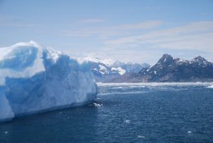 Some very impressive ice sculptures! Nothing to match the size of the blocks we saw in South Georgia (Southern Ocean) – those were often the same size as large buildings. Because the bergs tended to accumulate more on the west side, we were able to carefully make our way all the way up to the glacier!
  It was like stepping back into the Ice Age. Very impressive the power of scrapping glaciers to score the surrounding cliffs. We took lots of photographs, but by the time we made it to the top (about 12 miles,) it was getting late and very cold, so we came on back down the fjord and then up a side finger into a lovely anchorage protected behind a mound of old moraine. The icebergs are jammed along the other side – a bit like a train wreck. We enjoyed a super gorgeous, long sunset –
 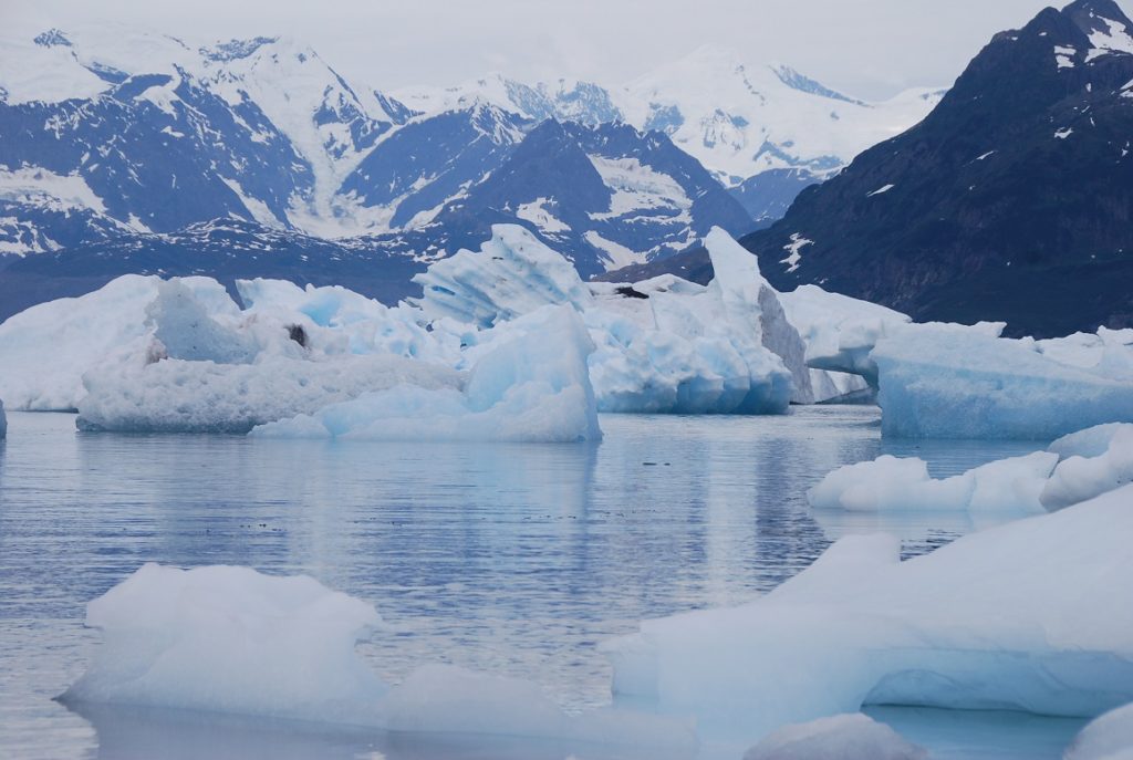 more pictures – we just can’t stop trying to capture the beauty and yet it is so vast, none of our photos really do it justice. Finally with the dark (not until nearly 11pm,) we settled into sleep, John setting his alarm to try and get up for some sunrise photos. Half way through the night we were startled awake by an ice berg bumping against our hull and the snap-crackle-pop of brash ice. John ended up pushing the hulk away with our boat hook! A bit cloudy this morning, so no sunrise photos. We have miles of moraine to walk and explore, so today will be a hiking day! I’m really looking forward to stretching my legs out a bit.
8/13/2012 – Columbia Glacier Explorations
We had a fantastic day yesterday hiking all over the place! We started the morning with a long hike up over and across a series of meadows/muskeg along up through the valleys, trying eventually to hike up high enough to get a super view. Unfortunately, the last tree crossing was also a cliff, so we didn’t get to the spot we’d been hoping for. Nonetheless, we saw a gorgeous fox and really enjoyed about 3+hours of tramping about.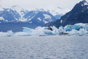 After some lunch, we took the dingy out around the moraine point puttering amongs the giant wreckage of icebergs – very surreal – and then took another long hike, about 3-4hrs, up around and about the moraine. Lots of seabirds and an incredible assortment of really tiny flowering vegetation.
 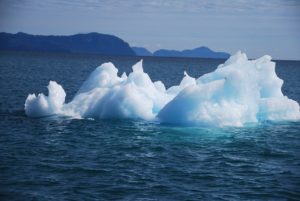 Fulfilled and tired, we gathered yet more glacial ice for our drinks and came back to relax in the cockpit and eat another dinner of halibut:)

Lots of bergs – ice sculptures floating in the water.
![]()
August 14, 2012 – 61-02.84N / 146-47.55W Sawmill Cove on a spectacular sunny day.
 We woke up to an absolutely beautiful day and couldn’t even think of leaving the Columbia Bay/Glacier areas. We went for two more long hikes – the morning one for nearly 5 hours! It’s just been fantastic to at last get out and walk – in fact we could have just gone on and on and on!!
We’ve anchored this evening about 2 hours away from Valdez and will go in tomorrow.
August 15, 20102 – Valdez Harbor 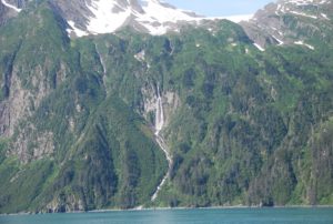
We may leave before Saturday. There is a music festival on the dock starting on Sat which might be fun, might just be noisy?!??! Not decided yet if we’ll stay, or if we can stay. People are worried about an early fall/winter, so lots of cruisers have already gone south or are busy getting ready to haul out. Sitka is only 465 miles away as the crow-flies, so we don’t really have far to go.
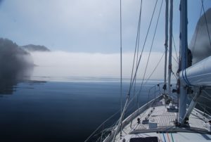
It’s foggy again, but at least calm.
![]()
August 18, 2012 – 60-55.98N / 146-39.97W Galena Bay We were surprised by sunshine yesterday which just got better and better:) After trying to troll for Coho (unsuccessfully) we motored on through the narrows and down to Galena Bay south of Valdez and are now anchored in a lovely little cove. As the evening progressed, the clouds eventually ALL disappeared and we were left with absolutely clear blue skies upon which the sunset began to gradually set the mountain vista into dark cutouts and cast its pallet of colors across the sky. Now I can totally relate to the painter Byron Birdsall’s style. We set outside for most of the evening just enjoying the peace and beauty of the moment.
Today started sunny, however the clouds are rolling in and starting to block out the sun. We’re off to Fidalgo Bay and will likely spend at least a couple of nights in that area.
August 18, 2012 – 60-50.97N / 146-32.13W
Landlocked Bay – a very dramatic mountain fjord
We dropped anchor about 3pm, just in time for the serious rain to start. Landlocked Bay is a dramatic mountain fjord with a jagged peak rising over 4000ft directly from sea level. Unfortunately, we only got to view it as we entered the fjord, by the time we’d settled, the clouds had descended and the view was obscured. What else to do, but put on the teapot and grab our books. I made pizza for dinner just to give us a break from halibut and add some extra warmth to the galley. It’s noticeable that our days are getting shorter – still long with the sun setting about 9pm and rising about 7am. This will mostly effect us on our longer passages. I really liked it when we had long days and could easily manage a 15+ hour sail with full daylight. Not sure how long we’ll linger in the Fidalgo Bay area. We’ll make some decisions this morning about the next few days at least.
Now it’s hot coffee and cranking up the heater.
August 20, 2012 ( 60-20.20N / 146-32.55W)
Garden Cove Hinchinbrook Island
We had a brisk 47 mile trip south from our snug little cove up in Fidalgo Bay – sad to leave the steep fjords – yet we’re both a bit restless to continue the journey. We’re anchored in Garden Cove at Hinchinbrook Island which is the launching place for leaving Prince William Sound and heading southeast across the Gulf of Alaska. At this time, the weather is predicted to be okay for us on Tuesday, but as Captain John likes to point out, it’s only a forecast. Tomorrow we’ll ready the boat for offshore sailing, something we haven’t really done for awhile as illustrated by all of the crashing and banging when we hoisted the sails this afternoon during a few hours of brisk winds! 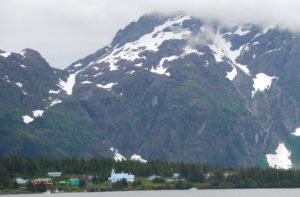 There is alot of history to the bay we’re in because the English and later the Russians valued the easy access of this bay to not only a rich source of sea otters, but also it’s ease of navigation using wind. Bad for the otters and the local native tribes – lots of bloodshed and violence – especially from the Russians. Now the Native village looks really lovely nestled amongst the rock formations and long sandy beach. The otters have robustly recovered (several met our boat as we came in to anchor,) and we even saw a big brown bear up by the river. I have my binoculars ready to keep looking for more:)
LATITUDE: 60-07.38N /LONGITUDE: 146-07.43W
COURSE: 127T; SPEED: 5.7
Surprisingly rough Hitchinbrook Pass. Lots of traffic – tankers and cruise ship
Leaving Prince William Sound and heading toward Kayak Island where we’ll decide whether to keep going southeast to Sitka, or go up to Yakutat, or perhaps toward Elfin Cove.
August 22-24, 2012
Two night passage from Prince Williams Sound down to Salisbury Sound. The weather is rapidly changing with snotty forecasts, so we’re planning to boogey our way quickly down south
We are on our way to SE AK from Prince William Sound. It is 4:20pm and a sunny afternoon with no wind so we are motoring. Right now we are approaching Cape St Elias – a very very rocky promontory that juts out into the Gulf of Alaska. We have to round that point, then make the turn for Yakutat. The charts that Scott sent us on a USB are the ONLY charts that show the detail of that point. There are many rocks and shallows that stretch out for 4 miles under water. Knowing that they are there has been very important to us in setting the right course. Amazing that no other charts show these rocks so well. The charts Scott sent us are the most up to date so we are safe thanks to you Well done Scott !!
August 22, 2012
LATITUDE: 59-48.74N /LONGITUDE: 145-03.66W
COURSE: 121T; SPEED: 7.0
Near Kayak Island sunny skies and calm seas
We pulled up the anchor at 6:00am this morning and headed around the Cape of Hitchenbrook Island having anticipated the benefit of leaving on an outgoing tide together with lighter winds. Good thing we did, because even with all of those variables in our favor, the trip through the pass was quite rough with disturbed waters and some large rolling and choppy waves – I can’t imagine what an ordeal it would be had we enountered stronger opposing winds against the strong tide! We encountered two oil tankers and a cruise ship while navigating through, so we stuck to the edge of the traffic separation lanes. Now 66 miles later, the seas are calm, the sun is out and we’re just about to motor around the cape of Kayak Island. Too bad there are no places to anchor there, it’s an impressive island/peninsula. We’ll continue through the night and depending on our progress, the weather, etc., will decide where to go.
LATITUDE: 59-20.09N /LONGITUDE: 142-08.59W
COURSE: 110T; SPEED: 7.3
Motoring along across the Gulf
We are still at sea and giving Yakutat a pass while we move ahead to either Lituya Bay or Touch or Graves Harbors. We’d both like to go into Lituya, but it can only be safely done at slack tide, which times well with or expected arrival, but not easy for a safe departure. We ended up with a gloriously sunny day yesterday, into the evening with sunset and then massive stars with nightfall. We’ll be at sea again tonight, but should each our destination tomorrow morning. John took a long shift last night – 1:30am to 6:00am, so I got a good night’s rest. Hopefully he’ll now sleep for 5-6 hours. The days are still longer here so we have from about 5am-10pm with daylight. Mostly motoring due to variable and light winds. Now they’ve strengthened but are directly behind us. It’s clouded over now which is a shame since we are missing some of the most dramatic mountain views. I so wanted to see Mt Fairweather.
August 23, 2012
LATITUDE: 58-57.58N /LONGITUDE: 140-10.73W
COURSE: 113T;SPEED: 7.1
Still motoring as the winds are directly behind us and not strong enough to keep our speed up. Hoping to arrive in Graves Bay early-mid morning. John and I are trading off on night-watch.
LATITUDE: 58-17.28N / LONGITUDE: 136-56.63W
COURSE: 121T; SPEED: 7.6
A couple of cruise ships in the distance and fishing boats. All is quiet and dark as we motor across the Fairweather Grounds.
LATITUDE: 58-16.52N/ LONGITUDE: 136-41.06W
Anchored in Graves Harbor
We just dropped the anchor in Graves Harbor on the outside edge of Glacier Bay Nature Reserve after completing our 384 mile passage across the Gulf of Alaska from Prince William Sound. No good sailing so lots of diesel used. Nonetheless, it was an easy and comfortable trip. We’ll stay here until a predicted gale passes through (1-2 nts) and then continue our way southward along the west side of Chichagof toward Sitka. Halibut for dinner with bacon, onions and cheese – actually turned out very delicious. We’re both knackered now and ready to sleep.
August 24, 2012 – Graves Harbor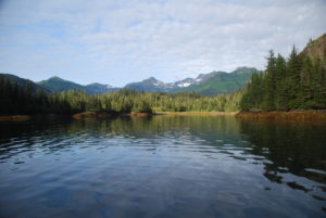
We’re waiting out the storm securely anchored in a lovely bay where I spotted a sow and her two cubs on the beach. Watching them with great delight, I realized that one of the cubs is lame. He must have injured his hips and/or leg so he could only hop his back end. Made me really sad to watch as his mother and the other cub kept getting further ahead and were still able to nibble at stuff while he/she spent all their energy just trying to move along the beach. I SOOOOO wanted to just go give him a big bear hug and bit of encouragement. Nature can be so cruel.
August 25, 2012
 Woke up this morning after a good long night’s sleep to find a big brown bear on the beach. He must be the papa to the two cubs we saw on the beach yesterday.
We’re waiting out a forecasted storm. Not that the winds and seas were more than Raynad could handle, but with large head seas and all the strong winds on the nose, progress would be tough. Our little bay is so well protected, it’s nearly flat calm in here and hard to imagine the forces of nature just outside! Meanwhile, big brownie keeps looking our way – I think he’s hungry and the tide is not out far enough yet to give him easy access to the jumping salmon. I just hope the little lame cub doesn’t come across him – the male browns like to eat the young cubs:(
August 26, 2012
5am and we’re just having our morning coffee and will raise the anchor soon to continue onwards towards Sitka. We’ll stop tonight and finish the trip on Sunday.
57-44.90N / 136-29.63W
COURSE: 155T; SPEED: 6.5
Motorsailing outside waters of Chichagof Island
We got up early this morning to try and make the right tides and distance so we can anchor at either Kalinin Bay or St John Baptist Bay before dark. LOTS of fishing boats out here – all trolling for Pinks -I think! Our trip is slowed a bit as we must continually dodge around all of the fishermen. There must be at least 50 trollers out here, all going different directions!?!? It’s a bit crazy at times when we come upon a batch of them. At least the seas are pretty calm, not much wind, so it’s a great day for the fishermen and a poor day for sailing. Good thing we have a super engine and lots of diesel.
 August 26, 2012 ( 57-19.24N / 135-47.18W)
Kalinin Bay SE Alaska
Sea Lion Cove. A couple of fishing boats are also anchored here. Mostly quiet in the growing SE mistiness.
August 27, 2012 – LATITUDE: 57-08.33N / LONGITUDE: 136-00.67W ; COURSE: 196T; SPEED: 7.3
Downwind offshore of Mt Edgecumbe – sunny day!
 We’ve set off under sunny skies with northwest winds to sail around Mt Edgecumbe and into Sitka!!
August 27, 2012
LATITUDE: 57-03.37N/ LONGITUDE: 135-21.13W
SITKA!!! Homeport in the harbor.
August 28, 2012, Sitka, AK
We just arrived into Sitka last night on an absolutely beautiful day of sunshine, including an amazingly raucous sail along the outside coast of Mt Edgecumbe. Downwind with 30kt/gusting 35kts. There were moments when I was all clinched fingernails as the boat swerved around. Once safely moored at the dock, out came that bottle of champagne which you two should have shared in Kodiak.  We toasted our safe arrival and made a toast to you as well, then enjoyed a lovely evening sunset from the cockpit. Avoiding the “real world” we spent the night on the boat and are now up for coffee with a full day’s/week’s list of to-dos.
Passage-Making
Sitka, AK to Anacortes, WA
Sept 2, 2012 – headed out Sitka Sound to outside waters for about 4 hours of beating into the weather before deciding to turn back and wait out this weather system.
Sept 4, 2012 (56-15.54N / 134-53.19W)
COURSE: 145T; SPEED: 7.2
Passed a huge pod of Humpback Whales!
Still Harbor Baranof Island
(56-32.45N/135-00.86W)
Whew! Nestled inside Still Harbor at last – was pretty rough outside with far too many water-sodden logs in the water. We’re ready for a break and peaceful overnight.
Sept 5, 2012
Egg Harbor in Coronation Island
(55-54.44N /134-18.94W)
We’ve just dropped anchor in Egg Harbor at the rather dramatic Coronation Island. I’ve flown over this in a small plane and always thought it’d be cool to be here AND the sun has come out! We had a much better day today – not enough wind in the right direction to sail, but at least the seas (waves and swell) were down a bit from yesterday. Nonetheless, the water disturbance around Cape Ommaney was incredible with sharp, steep waves and lots of lovely Puffins:) We even clocked 8.6kts of speed with the tide. Not sure what are plans are for tomorrow – depends on the weather if we sail or motor, stop or continue through the night. Will let you know.
For now it’s GTs/whiskey in the cockpit – our favorite time of day:)
Sept 6,2012 (54-50.64N /132-56.56W)
Port Bazar on Dall Island after a LONG day with flat seas and no wind
Sept 7, 2012 (54-37.04N / 132-43.09W)
COURSE: 094T
SPEED: 5.0
COMMENT: Downwind through Dixon Entrance
We sailing along through Dixon Entrance while listening to comedy on the satellite radio!! Yes, John took it out of he house and has done a partial installation on the boat. Very nice to have radio with such clear reception and a variety of program choices: opera, jazz, comedy, news…..:) We’re heading for Prince Rupert to check in to Canada before cruising southward. All is well onboard.
We’re about 40miles out from Prince Rupert on a lovely sunny evening. Lots of big ship traffic and we’ll be arriving after dark, so a bit nervous about that!?! Has been a beautiful day, started with strong winds and seas, but settle into a following sea and not enough wind to keep the sails full while going, so have motored.
Sept 8, 2012
Sailing south from Prince Rupert, BC – Canada
(54-12.40N /130-22.06W) ;COURSE: 211T; SPEED: 5.3
sunny day!
(54-22.20N / 131-12.56W) COURSE: 110T;SPEED: 7.4
(53-52.85N / 130-49.99W) COURSE: 173T;SPEED: 7.3
(52-51.82N / 130-07.00W) COURSE: 143T;SPEED: 6.0
lovely sunrise
(52-14.66N / 129-24.06W) COURSE: 149T;SPEED: 8.0
Well the trip started out with good winds out of Prince Rupert, but they dropped earlier than expected so we’re now motoring and trying to do so a bit more quickly to get into the protected waters inside Vancouver Island before the next weather system hits. It’s moving a bit faster than the forecast, hence Captain John’s decision to up the RPMs and move along a bit faster. Overall the weather has been lovely, clear skies and calm waters, with star and moonlit nights. Hopefully that will be the case tonight as we finish this passage across Queen Charlotte Sound. Lots of traffic including several cruise ships – our new AIS makes this all much less stressful as we know they are coming 25+miles out and also can follow their course, speed, etc tracking across our navigation software, plus we are broadcasting as well so if they are paying attention then they’ll know where we are too:) We mostly stay to the east side of the strait and leave the middle for the big guys to duke out for space.
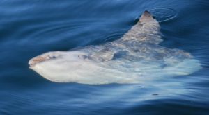 SUNFISH in Queen Charlotte Sound!
Well we’re only 36 miles from Port Hardy and boy are we ready to drop anchor!! It’s been a couple of days and nights with a variety of fickle weather- both glassy seas and dark stormy night with the wind not really making up its mind just from where and how hard it wants to blow. We set off from Prince Rupert under sunny skies and good winds, then the winds went on the nose, then eventually after 360 degree variations of sail changes, this afternoon, it was totally calm and glassy. Nonetheless, we just finished our crossing of Queen Charlotte Sound in gale force winds and in the black of night. Now we’re mostly motoring toward the Straits and are immersed in near total fog. Thank goodness for radar and AIS so we can hopefully spot any traffic along our way. Just before sunset, your dad spotted the most incredibly weird fish. We actually turned the boat around to go get a closer look of this thing sort of floating on the surface. Sad to say, it was one of the ugliest creatures I’ve ever seen, quite prehistoric like.  It sort of resembled a combo shark/halibut with lumpy skin, flippers like a whale, and seemingly missing its back quarter which was just scalloped off – not really a tail. The first one was pretty large and looked half dead. We then spotted a second one which must have been the “baby” and it actually sort of swam/floated about with an occasional flipper-flap. John took a bunch of pictures, so we’ll show them to you. Just as the sun finished setting, the wind kicked up and we took off sailing – quite nicely for awhile….then the fluky stuff started with winds up to 30kts, lots of gusts, a few direction changes and building seas. Neither of us is getting much sleep – John is snoozing now but we’ll both need to work on the navigation up the strait.
Sept 10, 2012
(51-25.35N / 128-32.17W) COURSE: 152T; SPEED: 6.0
Definite change of weather – Dark and stormy!
Sept 11, 2012
Port Hardy,BC – Canada (50-43.46N / 127-29.23W)
We arrived into Port Hardy this morning about 8:30, totally exhausted, in the fog and with lots of boat traffic…thank goodness for AIS and radar! The big boats were easy because they showed up on our AIS and we knew exactly where they were going, how fast, etc., the small zoom-around powerboats showed on the radar, but we had to depend on them zooming safely around us because we were only going 4-6kts and they were all powered up at 25+ – so typical of the charter sportfishing group, they seemed to love crossing right in front of us! We had a bit of everything on this 3 day- 2 night voyage from Prince Rupert to Port Hardy (about 364 miles)starting with sunshine and good sailing winds out of Prince Rupert, shifting winds, motorsailing, motoring over glassy waters under sunny/cloudy skies, then gale force winds,darkness, rain and fog, ending with no wind, opposing tide and thick fog. Captain John loved all of the sailing moments, even the gales, he tolerated the motoring on glassy waters (after all it really was pleasant and beautiful – we could even have a wee happy hour:) but he really hated the fluky winds/motor-sailing. As for me, I ALWAYS loved the calmer seas:) We had some lovely moments in Queen Charlotte Sound with a starlit night, whales, beautiful sunrise/sunset and even a couple of unique fish (perhaps Sunfish??)The Canadian weather forecasts were mostly wrong with our getting calm, fluky weather when we should have had good sailing winds or even storm winds, and gales as predicted but from a different direction?? Now our challenge will be working with the tides (and winds) as we progress down the inside passage of Vancouver Island. No more big seas, but a navigational challenge all the same. Nearly to Washington! We hope to arrive in Friday Harbor, San Juan Island on, or before Saturday-Sept 15. Then it’s just a short 20 mile hop over to Anacortes, WA.
After anchoring this morning, we both crashed for about 4 hours. John is now fixing the latest boat issue – or tank sentry/pump for the diesel day tank. He had to do several repairs during the passage, even install a new pump, but it’s still not working as it should. He is such a handy-man, I can’t imagine ever even considering cruising in a boat without someone like John who can repair almost any mechanical problem on the spot! Especially since the problems typically appear at the most inopportune times. He’s amazing!
(50-24.94N /125-58.79W) COURSE: 124T;SPEED: 7.0
Johnson Strait in rain, then sun, then rain, then sun!?
(50-21.09N /125-27.91W)
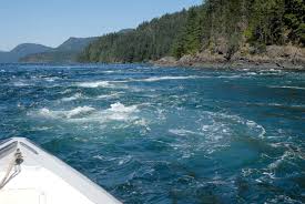 ‘Ripple Rock’ in Seymour Narrows – Fascinating !
(50-07.70N /125-21.32W)COURSE: 171T; SPEED: 10.5
10.5 kts through the Seymour Narrows – Yipee!
Anchored – Tranquil cove for my birthday celebration:)
(49-43.74N /124-12.68W)
After a VERY long day following an all night passage, we’re taking a break – no big celebration – mostly sleep!
Sept 12, 2012 – Anchored Overnight
(49-28.50N /123-51.52W)
Just a very short break before continuing on hoping to arrive in Washington before dark.
Sept 13, 2012 – ARRIVED ANACORTES,WASHINGTON -USA
Came into the marina with the last light after a long day. Brisk sailing at times with good winds, a bit of challenge with the tides, but all went well. Good day with sunshine and definitely much warmer than Alaska. We’re back into summer-like weather and it feels great!
Jodie drove up to meet us! Very exciting to see her again. She’ll let us use her car for a few weeks and she’ll commute to her UW Med School assignments via foot, bike or bus. We’ll leave the boat here for the winter and spend some time pestering our children! The marina only allows us to “live-a-board” for no more than 2 weeks, so we’ll need to find somewhere else to live, probably around Portland. Scott graduates from his CAD program and is looking for a job, so we’ll be here to be involved helping him with that. Plans are to set out next April and cruise more of Alaska. We rushed through SE Alaska and BC so we want to spend much more time in those places.