
2014 – SUMMER CRUISING AROUND THE GULF OF ALASKA witnessing her majestic beauty, amazing wildlife and lingering in some of the most remote places…
s/v Raynad kept us safe and comfortable. I really loved being able to enjoy the beauty from inside inside or cozy boat gazing out through the large pilothouse windows between trips ashore for hiking and beachcombing.

May 25, 2015
LATITUDE: 58-55.53N
LONGITUDE: 135-22.02W
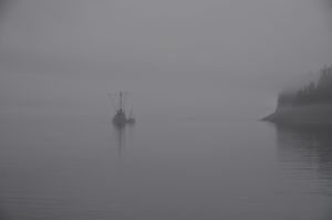
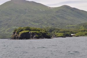
Sullivan Island.. SE Alaska.
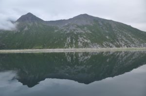
School is OUT for summer! Kris handed in the band room keys, John had the boat fueled and ready to go, we dropped the mooring lines from  Haines Harbor and made our way 12 mi on a gorgeous sunny day to drop anchor next to Sullivan Island. This is one of our favorite anchorages with towering peaks, glaciers, bears, sea lions….a perfect start for summer vacation.
May 27, 2014- Juneau, Auke Bay Harbor
May 28, 2014 -FUNTER BAY
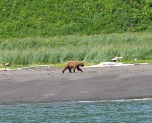
After lots and lots of shopping, stowing stuff away, taking on fuel, etc….we left Juneau and dropped anchor last night in Funter Bay and within 30 mins had a bear to watch grazing along the beach beside our boat:) It’s wonderful to sit in our warm and cozy pilothouse and look out at the world around us, especially when we get to observe bears!
 May 29, 2015
LATITUDE: 58-27.63N/ LONGITUDE: 135-53.11W
Arrived Bartlett Cove – Glacier Bay
Raynad is now anchored in Glacier Bay – at Bartlett Cove, just six days after Mum finished school. We have to check in here with the Ranger Station to make sure we know not exceed the speed limit of 13 knots which is silly because Raynad only goes at 7 knots. It’s also silly because the speed limit is to avoid ‘Whale Impacts’. How did they come up with the thirteen? I reckon it depends on the way that the whale is going. If it is going in the opposite direction the the closing velocity is 26 miles an hour which is enough to skewer any living thing. I would think they should have a traffic pattern such that whales were only allowed to drive on the right, then we could make some progress on avoiding collisions.
 May 30, 2014
LATITUDE: 58-34.73N/ LONGITUDE: 136-12.12W
Fingers Bay in Glacier Bay Nat’l Park typical SE misty day
We have cleared all the park details for entering Glacier Bay and even managed to get 2- 7 day permits (one in each name) so that we can wander around the various inlets for 10-12 days or so. Some long distances to travel up and back to view glaciers, lots of non-motorized area restrictions which are a bummer, but we’ll try to “row” the dingy I guess and maybe even sail!?!? Looked at renting kayaks but they wanted $55 per day, so that was a bit too steep. Typical SE misty, rainy day. John is putting on the kettle for another cuppa as I type:) Good afternoon to kick back and start another book. Might even start reading about ancient civilizations since that’s my new subject to teach next year.
May 31,2014 LATITUDE: 58-46.74N/ LONGITUDE: 136-29.06W
Blue Mouse Bay nice to be tucked away out of the cold winds
We are in Glacier Bay Park, cloudy skies, a bit of low cloud, but at least the winds have lessened for awhile so he boat is sitting still. Was blustery yesterday.
 June 2, 2014
LATITUDE: 59-01.09N /LONGITUDE: 137-01.75W
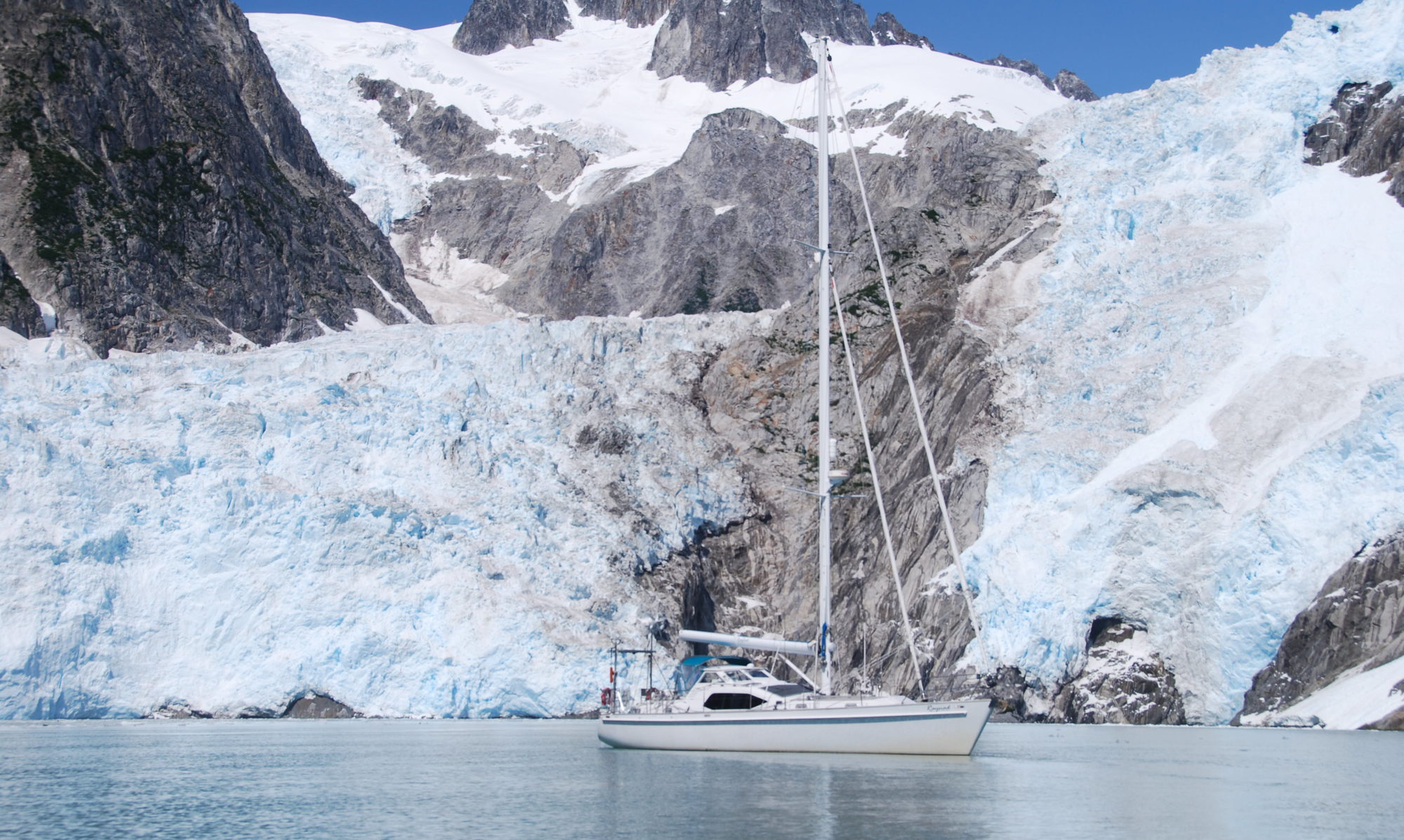
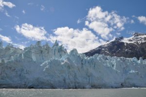
Foot of Margerie Glacier – beautiful sunny evening!
 We had a lovely evening with clear skies and totally enjoyed our anchorage just across from the glacier. Unfortunately as the tide went out, all the ice bits from the head of the bay came our way, including several larger bergs! With dreams of waking to a beautiful morning gazing out over the waters to a calving glacier, birds and wildlife around us….etc….we decided to just move our anchor a bit and stay the night despite the ice.
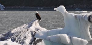
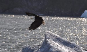
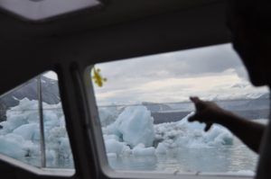 Not the best for a restful night. We both were up and down most of the night worrying over one particular iceberg that seemed determined to stay with us – what was at first a beautiful sculpted berg that not only looked like a swan but even had a couple of eagles perched upon it – John had taken lots of photos of it while were motored my.
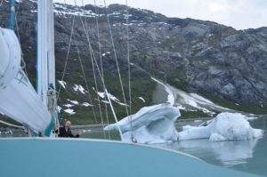 Finally at 5am, it was too much and too risky with the tide yet turning again and the swan looking more like a menacing dragon,
  we lifted anchor and are now just floating about waiting to see the big event of a large chunk calving off the face of Margerie Glacier.
June 4, 2014
LATITUDE: 58-55.57N / LONGITUDE: 136-48.39W
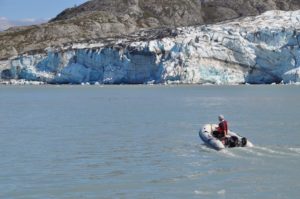
Yesterday started a bit hair-raising with our waking up at 4:30am to very large and menacing iceberg just off our stern! Captain John wrestled awake his grumbling crew (we’d been awake much of the night anyway watching with alarm the advancing bits of ice) and we lifted anchor. Within a few hours the gray skies started clearing and we had the impressive face of Margerie Glacier all to ourselves. 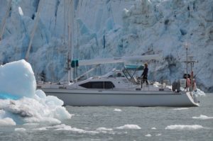 We enjoyed a glorious day just lingering around waiting for the ice to calve some of which were pretty dramatic.


John Hopkins Inlet – beautifully spectacular!
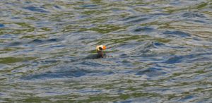
We were awakened this morning by a terrific thundering – I first thought it was a passing ship – John thought it was an earthquake – turns out that the Margerie Glacier was calving for over 15mins! Protected by Russell Island, we did not get any waves or even ice, but John was sure worried. After coffee, we took the dingy to shore and within 10mins came upon two bears in the midst of copulating! What a sight – we were far closer to them than my comfort level, but John was totally awed by the spectacle viewed from on top of a beach rock. Using the binoculars – they were like RIGHT THERE!?!?! Funny how we haven’t seen any bears at all since we entered Glacier Bay and then we come upon these two – amazing:) The only other wildlife we’ve seen was a lone wolf trotting along the beach. The terrain is full of blooming strawberry plants, paintbrush, other small wildflowers and thriving Fireweed yet to bloom.
Now we’re headed over to the Lamplugh Glacier and then to anchor in Reid Inlet for the night, with some more hiking on the moraine there.
It’s beautifully clear today – increasing blue skies and sunshine:)
June 4, 2014 58-55.57N/ 136-48.39W
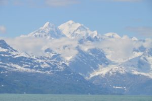 Sunny view over St Elias Mtns
We saw a bunch of mountain goats today!! 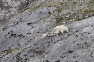 Really exciting and we were up close enough to see them without binoculars, although it was super cute to watch the little billy goats (kids) with their mothers:)There were two of them jumping around and trying to keep up as their mothers just walked up and down over the ledges – amazing world these little guys are born into. One of them got so tired, he just laid down when his mom finally got to a flatter spot.
 We’re anchored just around the corner from where we found them and are hoping for another look in the morning, or maybe even to see them cross over to our side for the morning sun.
 June 5, 2014. We’re in a unique anchorage spot right now – not one listed in the guide books, but hopefully ok for the night. It’s lovely though with the sun shining in the cockpit – GTs have been had on the deck and slaw salad eaten there as well:) Nice to have enough wind to keep the bugs away, yet a hard-dodger to shield us.
It’s been a beautiful day – the peaks and glaciers are incredible.
June 7, 2014 58-56.77N/ 136-18.44W
Washusett’s Inlet
We’ve had an incredible day starting with a coffee watching a herd of mountain goat, then a terrific hike up the mountainside with an outstanding vista out over Glacier Bay, St Elias Mountains and s/v Raynad bobbing in the bay below. A whale even blew by for awhile. We’re now further south in the bay and heading toward Muir Inlet which is actually closed to motorized vessels, but we can still go to Wachusett Inlet right next to Muir, so we’ll try that in the morning. It’s been stunningly sunny and beautiful – forecasts for winds and maybe rain tomorrow – so we’ve been filling the day as best we can.
 Raynad is sitting in glassy water in Adams Inlet – Glacier Bay National Park. It is 9am and we are on our second cup of coffee, sitting in our cozy pilothouse with the heater on. Out of the windows, the clouds are low and there is drizzle at times – very like the Weeping Glen – Glencoe. Kayakers have just slipped bye like Special Forces making a landing on a forbidden shore. We caught a big halibut last night but it got away – we will try again this am. Once we leave here we are looking at doing a four day passage across the Gulf of Alaska to Kodiak and maybe on along the Alaska Peninsula to Sand Point.
06/09/2014
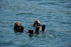
We had a peaceful walk along the beach of the fjord last night after dinner. Several piles of moose skat, yet no moose to be seen yet during this entire trip. Oddly, other than the mating bears and mountain goats, we have seen almost nothing – it’s almost spooky. Some fun marine-life at times: otters, sea lions, dolphins, a couple of whales and lots of sea birds.
Actually, we are mostly in solitude out here – almost no other boats and very few animals. Another rainy, gray, cloudy morning. We’ll probably start heading south to one more anchorage before getting to Bartlett Cove and then onwards. We need to do some laundry, Internet and would like to buy some fresh stuff, but we are too far from Gustavus to only walk, looks like it’ll just be whatever services we can find at the Glacier Bay Lodge.
06/10/2014 ADAMS INLET
Just as we were getting prepared to leave, a young moose came down to the beach. It was lovely and so timid as it nibbled on the beach plants, drank some water (must have wanted the salt?) all the time while looking behind it and out toward us – definitely worried. Within 15mins it wandered back into the bushes and disappeared. Then after leaving the inlet, John spotted a very large brown bear walking down the beach. We watched as it walked up toward a tidal pool, tested the water, and then went swimming! It was great. We thought that it might try to swim across the channel, but apparently, it just wanted a bath. Just like a dog, he shook and shook after exiting, jumped about a bit, then stood up on his hind legs to assess the grassy area and shot off back into the bushes!? So, a good day for wildlife. Now we are anchored in North Sandy Cove and immediately 2 barn swallows flew about the boat and then landed in our rigging looking pretty pleased with themselves.
 June 11, 2014 58-37.52N/ 136-18.84W
Peacefully at anchor in Shag Cove, Glacier Bay NP
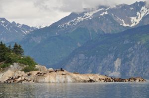
Snag Cove up Geike Inlet was a beautiful fjord to wake up in. Cliffs on one side and a waterfall on the other. After coffee we spent the day meandering about including visiting the many sea lion haul-outs around South Marble Island. Pretty spectacular to float around a lovely group of rocky islands watching (and smelling) sea lions in all of their funny antics while gazing over the back drop of the St Elias Mtns. We settled in South Sandy Cove around 5:30pm and immediately went to shore for a long walk around the bays. Lots of bear sign, but no encounters. Just as we were getting ready to leave the boat, a dolphin surfaced right next to us, rolling along as if curious to see just what we looked like. I was able to see its entire body only inches from the surface – it was magical:)
Probably headed into Bartlett Cove and the laundry tomorrow. We’ll need to decide our next course for action.
June 14, 2014 58-15.65N / 136-19.81W
Iniah Cove – Cross Sound Alaska
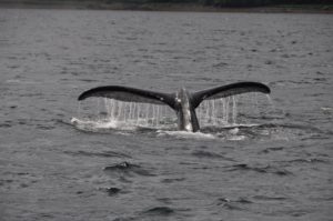
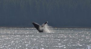
After taking on a little more diesel, we motored out of Glacier Bay with the outgoing tide. Not too impressive at the start as there as so many counter currents in the main entrance, but once we rounded the corner and were into Icy Straits – wow – we were going 8.4kts with only 1200rpms (the boat speed was as little as 2.6-3kts, but the speed over the ground was 8.4!)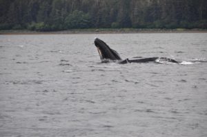 Loved the “free” miles. At the same time, a couple of whales suddenly started breaching and flipper/tail slapping, obviously feeding on the salmon that we have yet to be able to catch.
 It was an incredible show for about 15-20mins. There is something really beautiful about the whale body jetting up out of the water, turning in the classic pose and then falling back into the water. Really amazing. We aren’t seeing great volumes of wildlife, but we’ve definitely had some very unique sightings.
Unfortunately, the weather forecast is a bit stormy, so we are currently anchored and waiting out the weather in the lovely Iniah Cove. A strong minded fisherman has taken over the best spot in the cove having put in a higglety-piggelty dock/buoy arrangement and then strung a very large,long sign stating in large red letters, “Tourism Rapes Alaska.” I’m sure he was thrilled to see us pull in. Not the welcoming sort who is likely to bring us a gift of fish!?! It’s supposed to be a special wilderness area, so not sure how he is allowed to be so semi-permanent and obnoxious.
I’m back to making sourdough bread. My system is bake it when I first wake up, so now we have fresh bread for breakfast. Now if we can just get a fish or two on the line, we’ll be set.

06/15/2014
We are motoring our way up Idaho Inlet. I think John panicked when I brought out 2 decks of cards and started reviewing the rules for Canasta! He’s definitely NOT a card/game guy and he quickly came up with an alternate plan for what we should do. Actually, the weather has laid down a bit and we’ve had an incredible trip across Inian South Pass and across to Idaho Inlet (about 17 miles)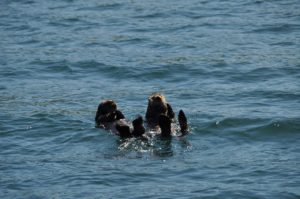 We’ve seen LOTS of whales – breaching, flipping – amazing shows. The place is active with marine life – dolphins following us, sea lions, harbor seals, porpoise and always lots of birds. It’s been a great afternoon – very unexpected. John just finished taking a photo of a beautiful rainbow with intense colors. We’ve 2 miles to go before we can anchor. Enchiladas are in the oven. Still no fish for us to eat yet – bummer – we just keep losing gear.
 June 15, 2014 58-15.65N / 136-19.81W
Idaho Inlet after day watching whales breach, dolphins and sea lions. Total solitude.
June 16, 2014 58-15.65N /136-19.81W
Father’s Day in Earl Cove on the east side of the Inian Islands
Woke up to a beautifully calm, misty morning at the head of Idaho Inlet at a minus low tide. We splashed the dingy into the water and motored ashore with high expectations for a long hike – but alas the sticky, gooey, mud and ongoing muddy marsh grasses shortened the walk. Got to watch a huge brown bear munch away in the grass – he/she will be massive once the salmon start running. Fabulous to have Jodie and Scott call John and wish him a Happy Father’s Day. A joyous start to the day. We were just on our way out of the inlet with hopes of catching some fish. Several hours later, no fish (except John caught a large, angry gray rockfish:( but the sun is shining, we have been entertained by more feeding, flapping, slapping Humpback Whales, lots of porpoise, sea lions, otters and even mating eagles. Now we are enjoying a sunny happy hour GT while anchored in Earl Cove – how fitting for Father’s Day:) We still have a great view out over the sound and can hear the whales and porpoise breathing around us. Pretty amazing.
Winds are supposed to be out of the northwest tonight so this should be a good anchorage. The nasty stuff is coming tomorrow PM, so we’ll move back over to Inian Cove, a very protected anchorage. Tomorrow AM should still be calm though, so we have high hopes for better fishing. At least we have some halibut left in the freezer, so I can make John yogurt halibut for his dinner.
June 19, 2014 58-16.00N / 136-04.42W
Icy Straights off Iceberg Point. One halibut so far. Yes, we finally caught a halibut!! Perfect size for 2 people – about 25-30lbs – giving us about 15-lbs or so of filet to enjoy over the next couple of weeks. Now we’re off back toward Inian Island and then out of Icy Straits, probably toward Lituya Bay tomorrow or the next day. We really liked all of the wildlife around Shaw Island, so may visit that again first and let the seas calm a bit more before motoring out. Kodiak may not be part of the itinerary this summer. We shall see. It seems to be an El Nino year with more weather systems passing through. We’re just out to have a good time – and that it was today catching a fish:)
06/20/2014
back in Inian Cove with plans to head out early in the morning. Looks like a good weather window for us. Very calm day today, tried a bit of halibut fishing, but only caught 4 rock fish and 2 cod. Lots of current, so it was difficult even anchored to get the line to the bottom. Some people who were next to us (and are now in this cove) moved over to our spot after we left and caught 4 small halibut! Of course, they have a fast, fancy boat while we had to move on and catch the last of the outgoing tide in order to get here. Last time we were in this cove, we had it all to ourselves. Now we are one of 5 boats?!?! We anchored first, the others came in about 1-2 hrs later.
GULF CROSSING: 58-16.00N / 136-04.42W
We are headed on a course of 270 toward Kodiak. We’ll see how it goes for today and keep you posted. Winds are forecast to swing SE and then E at a pretty good rate which will hopefully allow us to sail without getting crazy, rough. Of course, SE means moisture, so it’s rainy. Did not go to Lituya Bay because it’s 60 miles up the coast in the wrong direction – we had to make a choice north vs west. Saturday is also the Summer Solstice-appropriate for the Rock’n Roll Marathon! We’ll be out in the Gulf surrounded by water, let’s hope the skies clear and we get to view the sun as it circles around the horizon. The long days will be an advantage for night watches – I’ll enjoy less darkness:) So far we’re managing decent speed and calmer waters. Just put up the main and pulled out the Yankee. Kodiak is 525 miles from where we started.
June 21, 2014 58-12.50N/ 143-01.52W;Speed: 6.4; Course: 255T
We’ve had some brisk winds and rough seas, but are fine. Had good speed for awhile, but the seas are blocking that a bit. Nearly half-way there!!
We’re now 24 hrs into our sail across the Gulf – motorsailing with 6.5-7kt ave. Winds and seas have been building, especially the past few hours. This was in the forecast. Interestingly, even though we have 25-30kt winds, with everything coming from the East – winds and swell – we still need to use the motor to keep our stability and speed up. Raynad is holding up well, we’ve gone over 148miles so far and the trip is just over 520. We are both a bit rummy from lack of sleep and motion, but doing ok. Made some sourdough bread that just finished baking, but it had a rough go of it in the oven getting knocked back and forth. Still looks ok.
June 22, 2014- 58-10.72N /143-31.31W;Speed: 7.2; Course: 263T
We’re over half way across the Gulf toward Kodiak. Seas have had big rollers and the winds got up to 47kts earlier today, but have settled now into 25-30 for the most part. There is a low pressure system over the entire Gulf which we had hoped would dissipate as we moved along westward, but I guess it’ll stay with us. The wind and swell are behind us (from the East) which is causing the rolling. They will likely come around and come more from the north before we reach Kodiak. I always forget how tiring these long trips are. John and I are sharing erratic watches of 1-3 hrs, but sleep is difficult when no matter what your position, the boat rolls you around. We’re both sharing the window side of the settee with the lee cloth up and the jam a pillow between us and the table to try and wedge our bodies into some sort of calm.
2014/06/22 12:06; 58-11.57N/145-01.36W;Speed: 7; Course: 267T 2014/06/22 18:56; 58-07.65N /146-30.24W;Speed: 7.6;Course: 274T
Only 189 miles to go before we can drop the hook and have a LONG sleep in Kodiak! For now, the seas are better and winds more manageable, so we are making good progress on a downwind sail to Kodiak. Lots of low pressure systems hanging around, but the forecast is decent for our arrival. We’ve finally settled into a better watch routine, 3 hrs on/off, rather than our loose “whenever you’re awake” sort of mode which just resulted in neither of us getting sleep as every time we woke up, we’d feel the need to give the other a break – that combined with the rolly-polly ride (we have to wedge ourselves tight between the back of the settee and the table not to be continually rolling back and forth,)was not good. The longer days have been great because even last night when it was low dark clouds and rain, it was never totally dark. I like having visibility:)
2014/06/23 06:10:30; 57-59.57N/ 148-40.09W;Speed: 7.2;Course: 269T 2014/06/23 13:08:48; 57-55.55N/150-02.42WSpeed: 6.8
2014/06/23 17:04:08; 57-53.87N/ 150-51.82W;Speed: 7.1;Course: 265T
We are now 45 miles from Kodiak- sun is out – sails are out – looking good! We’re hoping to be there by 3-4pm today and will probably just go on into the harbor, eat, then sleep:)
2014/06/24 01:24:59; 57-46.79N/152-22.95W
Anchored Holiday Island Kodiak AK. Tsunami Warning in Effect. 8.0 Quake off Aleutians
Made it to Kodiak by 5pm and dropped anchor in the bay of a small island about 4 miles from town called Holiday Island. The crossing was more snarly than the forecasts led us to expect, very tiring, and then when we’re finally only 25 miles from Kodiak, the USCG comes on ch16 announcing an 8.0 earthquake on a tiny island in the Aleutians and issued a tsunami warning/alert!! Kodiak wasn’t high on the alert, but wow, we wondered if we’d have to spend the night at sea – again!?!? Fortunately, no big waves, Kodiak is cleared, and we have found a quiet little secluded bay.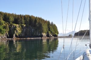
It’s a gorgeous evening, calm, lots of sunshine, birds are singing all around us and we’re nestled in a bay with alternating high rocky cliffs and gravel/sand beaches:) The topography around Kodiak is so different, very sculpted, emerald green and stunning in the sun. I’ve had my shower, now John will scrub up, then GTs, halibut fajitas and alas a LONG snooze. Life is good.
 June 27,2014 57-52.50N/ 152-38.00W
Anchored Larson Bay, Kodiak on our way to Sand Point AK
June 29, 2014
57-49.39N /153-19.06W
Anchored, Uganik Passage, Kodiak West
 June 30, 2013- 57-43.07N / 153-20.83W
Anchored, Sheep Is. Uganik Bay, Kodiak West
Little Villages-Scattered Cabins
This is an entirely different topography than what is found on the east side of Kodiak Island. There are no trees, only tall bushes and very, very tall grass. Looking out over the steep mountains and terrain, it appears like we could just walk and hike all over the place; however, when we went ashore yesterday, the grass was taller than me! A bit spooky to cross knowing that bears might lurk anywhere. Obnoxiously noisy, we managed a rather long hike between various lagoons. During the hike, we saw two deer and then once back on the boat, we saw two bears right where we’d first been walking. Pretty funny because one of the bears was on the beach and the other up above in the tall grass. The one above kept having to stand up to look at where the other bear was (they were clearly not together.) We had a good laugh because it reminded us a bit of a jack-in-the-box as it repeatedly would walk a bit, pop up and look around, then walk a bit more and pop up again – totally uncertain what to do about the other bear who was totally ignoring it except for the occasionally huff and puff.
This morning the tide was very low, so we took the little boat around to a neighboring bay where there is a Fish & Wildlife Recreation cabin. We were able to walk for about 2 hours around the beaches over there. A couple more deer, no bear, and lots of otter all rafted together (easily 35-45!) We left that spot and motored around to Village Islands, a rather enchanting spot nestled amongst rocky tufts of islands. Not really a village, just a bunch of scattered cabins and a few fishing boats, so we moved along down the passage and are now at the end of the northeast arm of Uganik Bay near Sheep Island. If it weren’t so cold, we’d almost believe that we were in southeast Asia. The bushy vegetation is thick and grows all the way down to the water, lots of birds singing and squawking, the rocky islets and cliffs are steep broken rock. Tomorrow, we will go over to Larsen Bay.
It’s a misty morning this AM, we are up early and already headed out the fjord to try and round the outside capes before the tide is too against us and the winds kick up. We were in a unique place last night with tall craggly mountain absolutely totally covered in willow or birch trees, various bushes and tall grass. Even the cliffs seem to drip with vegetation. I found it quite beautiful in an almost haunting way. The water was super clear. We took the inflatable out to explore several islet and little passes and were amazed that we could see the gravel bottom at least 12-15 feet below with absolute clarity. Wandering into a little horseshoe bay, we came upon a female bear with 5 cubs! Seriously, I had to keep recounting because I believe that must almost be a record. Two of them looked pretty healty, a third ok, but the other two were smaller and darker. They were so cute! She didn’t like us though and took off before we were able to get very close and of course the tumbling cubs followed right along.
 We’ll be over in Larson Bay tonight. It’s a favorite of the Kodiak people and hopefully we’ll get some fishing in over there. It’s a bit sparse so far. Even the commercial guys are complaining, so it’s not just us. We haven’t really tried much as we’re pretty busy moving about and exploring once we get to places.
June 30, 2014- 57-53.57N/ 153-47.90W; Speed: 6.6;Course: 245T
57-35.70N/ 153-36.75W
Weasel Cove Spiridon Bay, West Kodiak
Wow-we’re definitely in the right part of Alaska now! As we were pathetically trolling yet again through this fishy cove today, the commercial fishing boat who were in fact hauling it in, gave us a very large Sockeye! Then, while at the dock in Port Larson putting water in our tanks, the local peace officer (policeman) gave us a Tanner Crab! We have dined well tonight in our subsistence, boaty lifestyle. It’s late, 11pm, and we just finished eating…subsistence is alot of work…but very yummy:)The sun has been out all day, very hot and very beautiful. The winds for tomorrow are forecast to blow totally in the wrong direction for our next leg of travel, but who knows, it’s only a forecast.
July 4, 2014 – 57-30.76N/ 153-49.88W
Amook Island Lagoon east of Port Larson
July 5, 2014 – 57-38.70N / 154-00.51W
Harvester Island at sunset
 What a diverse day it has been – we started early this morning with calm seas and good weather motoring our way down the west coast of Kodiak Island past lots of long sandy beaches, fishing boats at every cape and even breaching whales; a couple of hours later we put up the sails and enjoyed some brisk sailing for only about an hour before the buster started building and we were heeled over flying at over 9 kts, great speed, but that was only the beginning of the winds and seas, so we reefed the mainsail and pulled out only the staysail, yet we were clicking along at 8kt.
 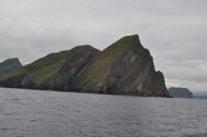 Because we were coming away from Kodiak Island with a shift in winds, the seas became irregular and quite uncomfortable; now we are once again motoring with only a light winds behind us. With Mozart on the stereo, we are enjoying the spectacular vistas over the many mountains of the Peninsula, especially grand is Mt. Chiginigak -a glacier clad volcano of 8000ft coming nearly strait up out of the ocean. We’re just over half way on what will likely be a 24-26hr trip. I’m hoping for a long and beautiful sunset over the mtn ranges:)
July 6, 0214
56-50.24N / 156-31.60W;Speed: 7.4;Course: 235T
With much relief, we dropped anchor early this AM in Chignik and were at last in bed about 6am. It’s now 1:20pm, we’ve finished our coffee and are ready to explore this little, misty fishing village. We are now totally beyond the “tree line” so just shrubbery and long, thick grasses. This is definitely a birds world down here with lots and lots of islets, steep cliff faces and miles of isolated ocean. We were continually entertained by their busyness. Chignik is located on the east side of a protected bay/inlet and surrounded by tall mountains and cliffs. We’ve anchored on a steep sloping beach near the harbor and church. They’ve built a road from one end to the other, so we’ll go walk that and see what we find. It’s a rainy Sunday, so nothing will be open.
We are sitting in the fog and rain still anchored in Chignik, but will leave soon and go around the corner to another bay about 28 miles away. At least with fog, we shouldn’t have too much wind, which is nice because Cape Castle can be pretty rough. We walked from one end of the town to the other yesterday. These two teenage girls kept roaring past us – one on a small motorbike and the other in a 4-wheeler – seemed to be racing each other. Small town entertainment! Otherwise, it was a pretty sleepy and quiet spot. We spoke with a fisherman, a couple of store people (one small grocery in a room off their kitchen, the other was the Trident Seafood store,) and a young boy/teen on the dock. They “haven’t caught a single fish yet this season!” Pretty tough for people here because they usually start running by June and yet the salmon haven’t arrived yet. New is that the salmon runs have hit in Bristol Bay and Prince Williams Sound, we saw a few boats out around Kodiak Island, but these runs haven’t been as large as expected and in this area, non-existent. There are some salmon out there, but not the big runs. So, not much chance yet for s/v Raynad to haul in the fish!?!?
They have a beautiful clinic building here with a van ambulance parked outside. Quite out of place against the small, rough, trailer-like places in the community. It’s pretty run down here with people living in various shacks of old wood, trailers, containers and/or a combination of these materials. No signs of any wealth except a couple of attempts to create fishing lodges, but even those are pretty sad looking. Apparently there is one health aid, so not sure how they fill the many offices we saw through the windows – guess it provides jobs and a few services. A regular flight just to Anchorage costs $1000 and the ferry only runs 1-2x per month.
We are in an enchanting place called Ross Cove. Surrounding this cove are crumbling mountains and huge deep valleys shrouded in misty clouds and drifting fog.
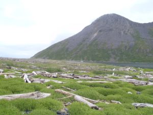
We expected a pterodactyl to swoop down on us at any moment and steal John’s hat! If we survived that then surely the Loch Ness Monster (or similar relative) would get us from behind. It’s like a setting from Tolkein’s Hobbit and Middle Earth. It’s so remote, it’s a bit creepy.  We have walked the long beach where we saw a hungry, skinny Red Fox with a big bushy tail, whom we followed along the spit as he/she eventually found a weasel carcass to chew on. The beach is strewn with massive amounts of timber, rusty old ship bits, old fishing nets, fish and bird skeletons….
July 9, 2014
55-58.74N/ 158-43.23W
Anchored in Mitrofania Harbor
Awoke to rain and fog this morning making our anchorage look even more mystical and prehistoric. Emerging from the fog we made passage along tall, dark brooding cliff faces noted to be over 2000ft high, but hauntingly disappearing into the clouds. Occasionally a brief break in the clouds would wisk us a view of some incredible spires, but mostly our views were restricted to only a few hundred feet at most. We are now anchored in Mitrophania Harbor just outside the shallow lagoon where we took our dingy and explored the narrow spit of land between here and Herring Cove. From the boat it looked to be an easy hike, however, when we got there we found tall grasses, bushes and some impressively huge dunes of gravel covered in wrecked timbers that sloped steeply down into the adjacent cove. Even on a calm day the waves were pounding against the rocks. Nonetheless, it was fun beachcombing, even doing a bit of beach art with buoys and scraps of rope. There is supposed to be an old settlement here, but after some additional exploration, we could only guess where it might have been and didn’t find any signs of previous inhabitants. Now we’re back on the boat, gently rocking and enjoying happy hour:) It’s our reward after all of the hard work launching the skiff and motor, then tucking them away again. Just made it before the rain. Cozy Raynad, fried halibut for dinner, life is good.
July 10, 2014- 55-46.51N /159-20.90W
Anchored in Kupreanoff Harbor – Sandy Beaches
July 11, 2014 – 55-36.67N / 159-38.08W
Fox Bay
We had a pleasant trip into Kupreanof Harbor located between Paul Island and Jacob Island. Before entering the bay, we passed over a long 10-20m sand area and decided to try and fish for halibut. 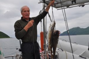 No luck with those, but within 5 minutes we had 3 cod-like fish (not yet fully identified) ranging from 5-7lbs each – good for some fish and chips type eating. Despite additional attempts, we just kept catching these buggers, so that was that! Not bad eating, not nearly as good as we’ve become accustomed to though:) Woke to a beautifully clear morning, so made our way out the south channel only to be met with increasing winds. Had some good sailing, some rough stuff and eventually ended up headed into these winds and swells to round all of the capes and make our entrance into Fox Cove. Not the protection we’d hoped for, but ok. Tomorrow we will travel the remaining 36 miles (5-6hrs)to Sand Point where we’ll meet Scott Saturday night! He leaves Portland on Sat AM and is able (weather permitting) to make it all the way via Anchorage to Sand Point, arriving at 6:45pm:) Sun is still shinning, we’ll hope it continues for Scott’s visit.
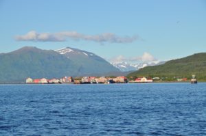
 July 12, 2014 – 55-20.03N /160-29.78W
S/V Raynad arrived Sand Point
 July 14, 2014- 55-35.57N /160-35.82W
anchored Albatross Bay with Scott on Board
Left the harbor about 2:00pm under a forecast of 15-25kt winds, but ended up with 25-45kt squally winds! Sand Point Harbor was much more protected than we had thought and the winds much stronger and more ENE than the E/SE forecasted. Always glad to be in a strong boat with a hard dodger for protection, a great engine and autopilot. I was a bit white knuckled at times, but Scott LOVED it, choosing to look out over the cover, riding the waves and swells like a practiced sailor:) We’re well anchored and all alone in this vast area of steep, green hills, craggy pinnacles and rocky/sandy beaches. Happy hour followed by dinner of more fresh Sockeye courtesy of a fisherman John & Scott met last night, plus movie & popcorn ….so life is warm and cozy aboard Raynad. The weather is supposed to be even more stormy tomorrow (hence our leaving today) so we’re planning to stay here and explore the beaches at low tide. Let’s hope the powers that be bring us a bit of sunshine and calm seas for at least a few of the days Scott is here. The country is so dramatic and different, it’s a shame for him not to really be able to see it. We’ll be back in Sand Point on Friday night for Scott’s Saturday PM departure.
So here we are, having braved the harsh oceans to take Scott on this fantastic cruise to experience the wilds of the Alaska Peninsula and it’s a big deal just to see a few seagulls and a couple of eagles!?!? Where is life? Oddly, we found a small, dead halibut that hadn’t even attracted birds or bears – a little spooky really. Best we can figure, this bay is perhaps a bit poluted with heavy metals from the very red, probably copper-filled mountains around us, so maybe not a great spot for salmon to breed, hence not a single jumping fish anywhere. The winds continue to howl and we’re visited by ocassional squals of rain. Tomorrow we’ll poke our nose out of this bay and either go north or southeast, depending on the winds and waves. Let’s hope the next spot brings more exciting wildlife – even the birdlife here is pretty dull. One, lone Loon was the only excitement (no guillemots, puffins or muirs here which is odd.) At least we had a good long walk around the bay at low tide and didn’t worry about bears since we only found one hole that a bear had probably dug and a few small bear prints, otherwise not even much sign of life.
 July 16, 2014
55-44.21N /160-08.66W
Anchored American Bay with Scott on Board
Happy Birthday for Scott drinking coffee and eating granola parfaits on a sleepy morning as Raynad sits on mirror calm waters surrounded by craggy crumbling cliffs and waterfalls.  We had a late night having gotten into this bay about 6pm, Scott did a bit of fishing (caught 3 sucker fish, one we kept for bait) and I made pizza which we followed with a late movie. Everyone slept in so it’s now 11am and we’re just getting done with breakfast! Lazy buggers! Going to launch the inflatable and do some exploring of the beach/valley. No signs of wildlife other than a few birds. I guess we’re just in the wrong area for viewing bears on the beaches and otters in the water. Could have chosen better, but we didn’t know. There is no cruising guide for this area, just the pilot guide about anchorages for commercial boats. I doubt that more than a handful of boats come into this bay each summer. Commercial fishing has been super slow along the Peninsula which has everyone worried.
 These are the fishing grounds for the Chignik Tribe and until they catch a certain number of salmon, no one else can come in to try and last we heard hey hadn’t caught a single fish in Chignik!?!? The Sand Point fishermen are fishing around the Shumagin Islands and have done alright there, but still under the usual. The distances are great here and with the uncooperative winds….it’s tough for us to move to a different region with Scott’s short visit. Yesterday we motored the 6 miles out of Balboa Bay with the wind gusting off and on between 15-25kts just off our port bow, but as we turned 120 degrees around the Cape, the wind just kept following us close on the nose and as we turned another 30 degrees to set our course, the wind stayed on our nose – go figure!?!? So, motor, motor, motor into the wind and seas we did for the 26 miles up here. Scott slept the whole way. We thought of heading off across the waters to a different anchorage, but with the west winds in the forecast, that would have meant getting headed and having a rough return, plus we’d been there and those bays were much more exposed with no special features. At least the scenery is very unique and stunning here. We might try to go into deeper water and see if Scott can drag up a halibut or something larger and more exciting for his birthday:) There is also some drift wood on the beach and I have hot links, so might do a bit of a beach fire. He wants chicken curry and lemon pie for his birthday supper – so that’s what we’ll do.
July 27, 2014
55-44.21N / 160-08.66W
Anchored Orzinsky Bay
(written by Scott)
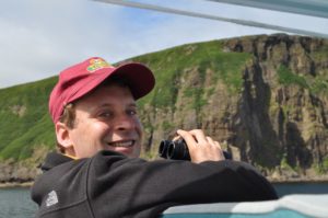
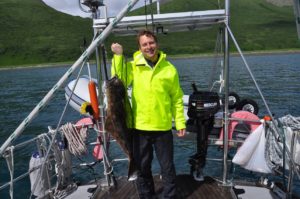 I caught a big halibut today, about 30 pounds! I’ve attached a small picture. Mum is cooking it for dinner. I also caught a cod and two rockfish.
 We met two people who were monitoring salmon. They gave us a live sockeye salmon! We invited them on the boat for awhile during my birthday. We also got to see their place and how they monitor salmon. Mom made some chicken curry. There was a vast beach where they stayed at where I saw a mother bear with three cubs and a male bear. There are a lot of puffins and seagulls in the ocean. I’ve also seen glaciers and there are a lot of mountains. The only negative is that everytime I go hicking through the grass, I get allergies. I am doing well.
July 18, 2014
55-44.19N/160-08.69W
back in American Bay
We had a fun time yesterday seeing the fish weir and meeting up with Kirsten, Karl and their two dogs (the dogs were SOOOO sweet:) and then coming back to the boat and fishing right from where we were anchored! Scott was very keen to hook some big fish and worked at it for several hours. The halibut had been playing with his bait for awhile before we finally hooked it – great eating last night! We shared a side of it, plus a goodie bag of coffee, beer and GT with Kirsten and Karl, just dropping it off with them at the beach as we desperately tried to keep from getting swamped in the growing wave action. Since that anchorage had been rolly-polly the night before and the winds were picking up, we came back around into the dramatically beautiful American Bay. Sunshine and great views – we had a lovely evening. We’re awakened at 4am with a strong wind shift bringing increased winds down off the mountains making Raynad swing and shutter about on it’s anchor and eventually drifting – that was some unexpected excitement. Now it’s a sunny, windy morning with coffee and fresh sourdough bread. We’ll head back to Sand Point (30miles) today since Scott leaves tomorrow night on the 7:30pm flight for an all-night return to Portland.
 July 19, 2014
55-20.38N/ 160-20.44W
Fox Hole – Lots of whales and puffins. Scotts last anchorage
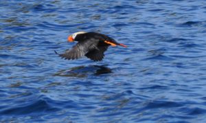
 A good day yesterday…lots of whales which we had not seen before and a huge colony of Horned Puffins absolutely filled the air. We sailed between the whales and the puffins – pretty nice. Scott was up on the bow snapping away with his camera. He was really excited about how close the whales kept coming to our boat (we were sailing.) Rather than go into Sand Point, we came around the east side of the island and are anchored in Fox Hole. It was on our way here that we had such a great showing of whales and puffins. Commercial fishing boats are all round so we’ll drop a line or two in the water on our way around to the harbor (about 8 miles) and hope to bring up something exciting:) Scott’s vacation has gone all too quickly. He leaves tonight on the 7:30pm flight and go all night arriving into Portland at 5:30am to start work on Monday.
July 19, 2014
55-20.01N /160-29.81W
back in Sand Point harbor
After a rough start to Scott’s visit with rain, gusty winds, low clouds and a dearth of wildlife, things just got better and better every day. American Harbor was stunningly beautiful and we enjoyed some great hiking to several huge waterfalls. Orzinski Bay brought sunshine, bears, Sockeye and halibut, plus the friendship of F&G weir workers Kirsten and Karl. But the crown of Scott’s week turned out to be an unexpected detour toward Fox Hole on the east side of  Unga Island (Sand Point) where we sailed through pods of Humpback and Fin Whales and an enormous colony of Horned Puffins on High Island. After Scott caught another large Pacific Cod following breakfast, we trolled around the other side of High Island and enjoyed even grander views of the puffins (literally thousands of them – they looked like a swarm of bees!) plus a large group of Sea Lions lounging in the sun – boy did they put up a fuss when we showed up, but only two of them left their ledge. Then as we came around the island, a bunch of fin whales were feeding and just kept coming towards our boat, one swam literally right under the bow where Scott was watching! It was amazing,(even a bit scary) they just loved hanging around the boat. I’d stopped and they sauntered away, but when we started up again, they came back!?!? Scott got some great photos even with his small little camera and was super excited about the whole encounter. It was a terrific finish for his holiday and made John and I feel so much better about our choice of journeying all the way across the Gulf and rendezvousing with Scott in Sand Point. He’s now on Penn Air and headed to Anchorage for his red-eye trip to Portland. It sure was nice having him on board and getting a chance to share some unique experiences.
July 21, 2014
55-20.44N / 160-20.42W
 Fox Cove – Depart in am to cross Gulf to Sitka – 5-6days
John and I motored around back toward the Fox Hole anchorage that we experienced with Scott. Once again, we were awestruck by the amount of life happening around this one rather smallish island. The Fin Whales swam toward our boat, although not nearly as dramatically as before, there were lots of Puffins and the Sea Lions continued their grunting complaints. The water was so calm and the scenery so delightful, we just decided to make a couple of GTs and just bobb around on the water watching everything. It was a perfect way to finish this leg of our cruising season. It’s sort of tough to leave just now because the weather is warm, sunny and pretty calm. We haven’t had very many calm, sunny days this summer so we are really relishing in and absorbing the moment.
GULF CROSSING, SAND POINT to SITKA
July 21, 2014
55-21.99N / 160-05.70W; Speed: 6.3; Course: 78T
After a lovely morning coffee watching the Horned Puffins and Sea Lions on High Island, we’re now heading out into the Gulf of Alaska, all sails flying, 17kts wind and sunshine. We’ll pass the other Shumagin Islands south and see bits of the south end of Kodiak and the higher mountains of the Alaska Peninsula for awhile. We expect this passage to take about 5 days. Where we land will depend on the winds and weather since we could either go into Sitka or Cross Sound toward Juneau. We so appreciated having a few nice days around the Sand Point area prior to Scott’s and our leaving.
July 22, 2014
55-35.28N / 158-26.43W; Speed: 7.0; Course: 79T
Although we had some decent winds to start the voyage, they have continued to lighten so we are motoring. Nonetheless, there is still a swell on our beam, so we are rocking our way back and forth along the ocean. Just spotted a small pod of Killer Whales, the first that we’ve seen this summer. We can only guess that the fish jumps and splashes that we then saw ahead were likely due to that same pod!??!
July 22 -continued
56-05.53N / 154-52.33W;Speed: 8.1; Course: 80T
We’re surfing along the waves with 20kt winds and a bit of a current behind us managing 8kts, which is good for us. We’ve gone about 200miles so far. Some fun bits were seeing a pod of Killer Whales last night and then John had a flock of small Storm Petrels flying all about the boat during is late night watch. They seemed fascinated by the lights and sails, dashing in and out between the sails and even crashing into them and sliding down onto the boom – and one even landed in the cockpit! John gave it a bit of a rest and then carefully picked it up and launched it into the wind:) Skies are waters are gray, gloomy and frothing, but there is hope that the sun will break through for at least a part of the day. We have podcasts and lots of seabirds to amuse us.
With no moon, it’s super dark out! Seas are a bit rougher than I’d hoped they would be and suprisingly so with the winds. In the South Pacific, we would never get such rough seas out of 20kt winds. At least they are lots better than on the way over. I’ll be glad when things settle down even if it means motoring.
July 23, 2014
56-08.58N / 151-12.57W; Speed: 7.1; Course: 83T
Was a roughish night motorsailing downwind with rather large seas swooping the boat about. Captain John let me sleep through all of the darkness waking me with the sunrise to change the sails. He had headed off rather than get me up to change the main during the night. With no moon, it’s super dark and can be very disorienting. Fortunately we caught a calmer moment and were able to manage the main without mishap. Now we’re only using the Yankee (foresail) because it’s much easier to change and manage with the big swell and gusty winds that vary from 15-30kts. Despite the boat movement, my coffee addiction prevails and I did manage one cup of drip coffee:) John is fast asleep and hopefully will be able to get a long rest.
July 23 – continued
56-08.58N / 151-12.57W;Speed: 7.1; Course: 83T
Although we had lots of seabirds while transversing through islands and around the cape of Kodiak Island, now that we’re out in the Gulf, most of the birds are gone and we only see the whale. We had some fishing traffic while over the Albatross Banks, but even that is gone. We’re pretty much alone out here.
We’re back to having small fast Storm Petrels and Sooty Shearwaters soaring around the boat, even the occasional Black Footed Albatross flies by. The Petrels like to fly between the sails, the Shearwaters investigate the wind generator or just give us the eye as they fly over the cockpit:) They are lovely. Winds and seas are settling into their new west setting pattern and the sun keeps peeking out between the clouds. One large fuel tanker, but otherwise no other boat traffic. That was a bit of excitement though as, believe it or not, we were on a collision course – go figure – all this wide open ocean and the only traffic we have for over 15 hours is headed right for us!?!? Love the AIS system though, so we had lots of warning and were able to call out to the bridge on the tanker; that was a comedy of it’s own as the heavily accented guy on their radio tried to communicate with me. First things got worse as they turned more toward us, and finally they really altered course the opposite way so we were a good 2.5 miles apart when they crossed behind us.
July 24, 2014
56-37.85N / 146-26.89W; Speed: 8.0;Course: 81T
Overnight the winds have died and the seas have calmed, now we’re just swaying along as we motor our way across. Should be like this all day before the winds start building from the SE. We’re hoping to be nearly to Sitka before that happens as it will head us and make that progress more challenging. We chose to go so quickly after Scott left because we still had a forecast for W, SW or NW winds. Anything E or SE will make it more difficult for us to make good time as the seas here build quickly and smashing into the winds, waves and seas tough going. All-in-all, sailing in Alaska is very different from the South Pacific. In the south we had more dependable trade winds which tended to be pretty steady, minus squals, and didn’t seem to kick up so much swell. I also have to remind myself that making this Gulf of AK crossing is much like making the big trips to and from New Zealand.
Time: 2014/07/24 20:25:34
Latitude: 56-40.88N
Longitude: 145-03.47W
Speed: 7.1
Course: 85T
to be continued…….